Uni-RS: A Spatially Faithful Unified Understanding and Generation Model for Remote Sensing
Proceedings of the Thirty-Fifth International Joint Conference on Artificial Intelligence. Main Track. Pages 2073-2081.
https://doi.org/10.24963/ijcai.2026/231
Keywords
- Computer Vision: Vision, language and reasoning
- Natural Language Processing: Language models
- Computer Vision: Image and video synthesis and generation
Abstract
Unified remote sensing multimodal models exhibit a pronounced spatial reversal curse: although they can accurately recognize and describe object locations in images, they often fail to faithfully execute the same spatial relations during text-to-image generation, where such relations constitute core semantic information in remote sensing. Motivated by this observation, we propose Uni-RS, the first unified multimodal model tailored for remote sensing, to explicitly address the spatial asymmetry between understanding and generation. Specifically, we first introduce explicit Spatial-Layout Planning to transform textual instructions into spatial layout plans, decoupling geometric planning from visual synthesis. We then impose Spatial-Aware Query Supervision to bias learnable queries toward spatial relations explicitly specified in the instruction. Finally, we develop Image–Caption Spatial Layout Variation to expose the model to systematic geometry-consistent spatial transformations. Extensive experiments across multiple benchmarks show that our approach substantially improves spatial faithfulness in text-to-image generation, while maintaining strong performance on multimodal understanding tasks like image captioning, visual grounding, and VQA tasks.
- [Bai et al., 2025a] Shuai Bai, Yuxuan Cai, Ruizhe Chen, Ke- qin Chen, Xionghui Chen, Zesen Cheng, Lianghao Deng, Wei Ding, Chang Gao, Chunjiang Ge, Wenbin Ge, Zhifang Guo, Qidong Huang, Jie Huang, Fei Huang, Binyuan Hui, Shutong Jiang, Zhaohai Li, Mingsheng Li, Mei Li, Kaixin Li, Zicheng Lin, Junyang Lin, Xuejing Liu, Jiawei Liu, Chenglong Liu, Yang Liu, Dayiheng Liu, Shixuan Liu, Dunjie Lu, Ruilin Luo, Chenxu Lv, Rui Men, Lingchen Meng, Xuancheng Ren, Xingzhang Ren, Sibo Song, Yu- chong Sun, Jun Tang, Jianhong Tu, Jianqiang Wan, Peng Wang, Pengfei Wang, Qiuyue Wang, Yuxuan Wang, Tian- bao Xie, Yiheng Xu, Haiyang Xu, Jin Xu, Zhibo Yang, Mingkun Yang, Jianxin Yang, An Yang, Bowen Yu, Fei Zhang, Hang Zhang, Xi Zhang, Bo Zheng, Humen Zhong, Jingren Zhou, Fan Zhou, Jing Zhou, Yuanzhi Zhu, and Ke Zhu. Qwen3-vl technical report. arXiv preprint arXiv:2511.21631, 2025.
- [Bai et al., 2025b] Shuai Bai, Keqin Chen, Xuejing Liu, Jialin Wang, Wenbin Ge, Sibo Song, Kai Dang, Peng Wang, Shijie Wang, Jun Tang, Humen Zhong, Yuanzhi Zhu, Mingkun Yang, Zhaohai Li, Jianqiang Wan, Pengfei Wang, Wei Ding, Zheren Fu, Yiheng Xu, Jiabo Ye, Xi Zhang, Tianbao Xie, Zesen Cheng, Hang Zhang, Zhibo Yang, Haiyang Xu, and Junyang Lin. Qwen2.5-vl techni- cal report. arXiv preprint arXiv:2502.13923, 2025.
- [Berglund et al., 2024] Lukas Berglund, Meg Tong, Maxim- ilian Kaufmann, Mikita Balesni, Asa Cooper Stickland, Tomasz Korbak, and Owain Evans. The reversal curse: LLMs trained on "a is b" fail to learn "b is a". In The Twelfth International Conference on Learning Represen- tations, 2024.
- [Chen et al., 2025a] Jiuhai Chen, Zhiyang Xu, Xichen Pan, Yushi Hu, Can Qin, Tom Goldstein, Lifu Huang, Tianyi Zhou, Saining Xie, Silvio Savarese, et al. Blip3-o: A fam- ily of fully open unified multimodal models-architecture, training and dataset. arXiv preprint arXiv:2505.09568, 2025.
- [Chen et al., 2025b] Xiaokang Chen, Zhiyu Wu, Xingchao Liu, Zizheng Pan, Wen Liu, Zhenda Xie, Xingkai Yu, and Chong Ruan. Janus-pro: Unified multimodal understand- ing and generation with data and model scaling. arXiv preprint arXiv:2501.17811, 2025.
- [Fiaz et al., 2025] Mustansar Fiaz, Hiyam Debary, Paolo Fraccaro, Danda Paudel, Luc Van Gool, Fahad Khan, and Salman Khan. Geovlm-r1: Reinforcement fine-tuning for improved remote sensing reasoning. arXiv preprint arXiv:2509.25026, 2025.
- [Hu et al., 2025] Yuan Hu, Jianlong Yuan, Congcong Wen, Xiaonan Lu, Yu Liu, and Xiang Li. Rsgpt: A remote sens- ing vision language model and benchmark. ISPRS Journal of Photogrammetry and Remote Sensing, 224:272-286, 2025.
- [Khanna et al., 2024] Samar Khanna, Patrick Liu, Linqi Zhou, Chenlin Meng, Robin Rombach, Marshall Burke, David B. Lobell, and Stefano Ermon. Diffusionsat: A generative foundation model for satellite imagery. In The Twelfth International Conference on Learning Represen- tations, 2024.
- [Kuckreja et al., 2024] Kartik Kuckreja, Muhammad Sohail Danish, Muzammal Naseer, Abhijit Das, Salman Khan, and Fahad Shahbaz Khan. Geochat: Grounded large vision-language model for remote sensing. In Proceedings of the IEEE/CVF Conference on Computer Vision and Pat- tern Recognition, pages 27831-27840, 2024.
- [Köksal and Alatan, 2025] Aybora Köksal and A. Aydın Alatan. Tinyrs-r1: Compact vision language model for remote sensing. IEEE Geoscience and Remote Sensing Letters, 22:1-5, 2025.
- [Li et al., 2024] Xiang Li, Jian Ding, and Mohamed Elho- seiny. Vrsbench: A versatile vision-language benchmark dataset for remote sensing image understanding. Advances in Neural Information Processing Systems, 37:3229-3242, 2024.
- [Li et al., 2025] Kaiyu Li, Zepeng Xin, Li Pang, Chao Pang, Yupeng Deng, Jing Yao, Guisong Xia, Deyu Meng, Zhi Wang, and Xiangyong Cao. Segearth-r1: Geospatial pixel reasoning via large language model. arXiv preprint arXiv:2504.09644, 2025.
- [Li et al., 2026] Wenshuai Li, Xiantai Xiang, Zixiao Wen, Guangyao Zhou, Ben Niu, Feng Wang, Lijia Huang, Qiantong Wang, and Yuxin Hu. Georeason: Aligning thinking and answering in remote sensing vision-language models via logical consistency reinforcement learning. arXiv preprint arXiv:2601.04118, 2026.
- [Liu et al., 2023] Haotian Liu, Chunyuan Li, Qingyang Wu, and Yong Jae Lee. Visual instruction tuning. Advances in neural information processing systems, 36:34892-34916, 2023.
- [Liu et al., 2025a] Chenyang Liu, Keyan Chen, Rui Zhao, Zhengxia Zou, and Zhenwei Shi. Text2earth: Unlocking text-driven remote sensing image generation with a global- scale dataset and a foundation model. IEEE Geoscience and Remote Sensing Magazine, 2025.
- [Liu et al., 2025b] Jiaqi Liu, Lang Sun, Ronghao Fu, and Bo Yang. Towards faithful reasoning in remote sensing: A perceptually-grounded geospatial chain-of- thought for vision-language models. arXiv preprint arXiv:2509.22221, 2025.
- [Luo et al., 2024] Junwei Luo, Zhen Pang, Yongjun Zhang, Tingzhu Wang, Linlin Wang, Bo Dang, Jiangwei Lao, Jian Wang, Jingdong Chen, Yihua Tan, et al. Skysensegpt: A fine-grained instruction tuning dataset and model for remote sensing vision-language understanding. arXiv preprint arXiv:2406.10100, 2024.
- [Pan et al., 2025] Xichen Pan, Satya Narayan Shukla, Aashu Singh, Zhuokai Zhao, Shlok Kumar Mishra, Jialiang Wang, Zhiyang Xu, Jiuhai Chen, Kunpeng Li, Felix Juefei-Xu, Ji Hou, and Saining Xie. Transfer be- tween modalities with metaqueries. arXiv preprint arXiv:2504.06256, 2025.
- [Tang et al., 2024] Datao Tang, Xiangyong Cao, Xingsong Hou, Zhongyuan Jiang, Junmin Liu, and Deyu Meng. Crs- diff: Controllable remote sensing image generation with diffusion model. IEEE Transactions on Geoscience and Remote Sensing, 2024.
- [Team, 2024] Chameleon Team. Chameleon: Mixed- modal early-fusion foundation models. arXiv preprint arXiv:2405.09818, 2024.
- [Wang et al., 2024] Xinlong Wang, Xiaosong Zhang, Zhengxiong Luo, Quan Sun, Yufeng Cui, Jinsheng Wang, Fan Zhang, Yueze Wang, Zhen Li, Qiying Yu, et al. Emu3: Next-token prediction is all you need. arXiv preprint arXiv:2409.18869, 2024.
- [Wang et al., 2025a] Di Wang, Shunyu Liu, Wentao Jiang, Fengxiang Wang, Yi Liu, Xiaolei Qin, Zhiming Luo, Chaoyang Zhou, Haonan Guo, Jing Zhang, et al. Geozero: Incentivizing reasoning from scratch on geospatial scenes. arXiv preprint arXiv:2511.22645, 2025.
- [Wang et al., 2025b] Fengxiang Wang, Mingshuo Chen, Yueying Li, Di Wang, Haotian Wang, Zonghao Guo, Zefan Wang, Shan Boqi, Long Lan, Yulin Wang, Hongzhen Wang, Wenjing Yang, Bo Du, and Jing Zhang. GeoLLaVA-8k: Scaling remote-sensing multimodal large language models to 8k resolution. In The Thirty-ninth An- nual Conference on Neural Information Processing Sys- tems, 2025.
- [Wei et al., 2022] Jason Wei, Xuezhi Wang, Dale Schuur- mans, Maarten Bosma, Fei Xia, Ed Chi, Quoc V Le, Denny Zhou, et al. Chain-of-thought prompting elicits reasoning in large language models. Advances in neural information processing systems, 35:24824-24837, 2022.
- [Wu et al., 2025] Chenfei Wu, Jiahao Li, Jingren Zhou, Jun- yang Lin, Kaiyuan Gao, Kun Yan, Sheng-ming Yin, Shuai Bai, Xiao Xu, Yilei Chen, et al. Qwen-image technical report. arXiv preprint arXiv:2508.02324, 2025.
- [Xia et al., 2018] Gui-Song Xia, Xiang Bai, Jian Ding, Zhen Zhu, Serge Belongie, Jiebo Luo, Mihai Datcu, Marcello Pelillo, and Liangpei Zhang. Dota: A large-scale dataset for object detection in aerial images. In Proceedings of the IEEE conference on computer vision and pattern recogni- tion, pages 3974-3983, 2018.
- [Xie et al., 2024] Enze Xie, Junsong Chen, Junyu Chen, Han Cai, Haotian Tang, Yujun Lin, Zhekai Zhang, Muyang Li, Ligeng Zhu, Yao Lu, et al. Sana: Efficient high-resolution image synthesis with linear diffusion transformers. arXiv preprint arXiv:2410.10629, 2024.
- [Xie et al., 2025] Jinheng Xie, Weijia Mao, Zechen Bai, David Junhao Zhang, Weihao Wang, Kevin Qinghong Lin, Yuchao Gu, Zhijie Chen, Zhenheng Yang, and Mike Zheng Shou. Show-o: One single transformer to unify multi- modal understanding and generation. In The Thirteenth International Conference on Learning Representations, 2025.
- [Xu et al., 2023] Yonghao Xu, Weikang Yu, Pedram Ghamisi, Michael Kopp, and Sepp Hochreiter. Txt2img- mhn: Remote sensing image generation from text using modern hopfield networks. IEEE Transactions on Image Processing, 32:5737-5750, 2023.
- [Yang et al., 2025] Yueguang Yang, Jiahui Qu, Ling Huang, and Wenqian Dong. Dpmamba: distillation prompt mamba for multimodal remote sensing image classifica- tion with missing modalities. In Proceedings of the Thirty- Fourth International Joint Conference on Artificial Intelli- gence, IJCAI '25, 2025. IJCAI
- [Yerramilli et al., 2025] Sahiti Yerramilli, Nilay Pande, Ry- naa Grover, and Jayant Sravan Tamarapalli. GeoChain: Multimodal Chain-of-Thought for Geographic Reasoning, September 2025.
- [Yu et al., 2024] Zhiping Yu, Chenyang Liu, Liqin Liu, Zhenwei Shi, and Zhengxia Zou. Metaearth: A generative foundation model for global-scale remote sensing image generation. IEEE Transactions on Pattern Analysis and Machine Intelligence, 2024.
- [Zhang et al., 2024a] Wei Zhang, Miaoxin Cai, Tong Zhang, Yin Zhuang, and Xuerui Mao. Earthgpt: A universal multi-modal large language model for multi-sensor image comprehension in remote sensing domain. IEEE Transac- tions on Geoscience and Remote Sensing, 2024.
- [Zhang et al., 2024b] Zhuosheng Zhang, Aston Zhang, Mu Li, hai zhao, George Karypis, and Alex Smola. Mul- timodal chain-of-thought reasoning in language models. Transactions on Machine Learning Research, 2024.
- [Zhang et al., 2025] Xinjie Zhang, Jintao Guo, Shanshan Zhao, Minghao Fu, Lunhao Duan, Jiakui Hu, Yong Xien Chng, Guo-Hua Wang, Qing-Guo Chen, Zhao Xu, et al. Unified multimodal understanding and generation models: Advances, challenges, and opportunities. arXiv preprint arXiv:2505.02567, 2025.
- [Zhao and Shi, 2021] Rui Zhao and Zhenwei Shi. Text-to- remote-sensing-image generation with structured genera- tive adversarial networks. IEEE Geoscience and Remote Sensing Letters, 19:1-5, 2021.
- [Zhou et al., 2024] Chunting Zhou, Lili Yu, Arun Babu, Kushal Tirumala, Michihiro Yasunaga, Leonid Shamis, Jacob Kahn, Xuezhe Ma, Luke Zettlemoyer, and Omer Levy. Transfusion: Predict the next token and diffuse images with one multi-modal model. arXiv preprint arXiv:2408.11039, 2024.
References were extracted automatically from the PDF and may contain errors.
Full text extracted automatically from the PDF; figures, tables and equations may differ. The PDF is the version of record.
1 Introduction
The evolution of Multimodal Large Language Models (MLLMs) is shifting from perception-centric architectures towards unified frameworks capable of both understanding and generation [Zhang et al., 2025]. In the context of Remote Sensing (RS), this shift is particularly transformative. A unified model can serve as a generative simulator [Yang et al., 2025; Liu et al., 2025a], synthesizing samples for datascarce scenarios (e.g., disaster aftermaths), while facilitating language-driven image editing (e.g., removing cloud artifacts). While unified multimodal understanding and generation have been widely explored in general domains [Team, 2024; Xie et al., 2025; Pan et al., 2025], to the best of our knowledge, such a unified framework has not yet been studied in the field of remote sensing.
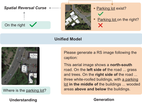
However, adapting unified models to the RS domain presents unique challenges. Unlike natural images typically centered on salient objects, RS imagery is characterized by a "bird's-eye view" [Xia et al., 2018], featuring high object density and intricate spatial layouts, where spatial relations are as semantically critical as the objects themselves. When standard unified models are directly adapted to the remote sensing domain, a critical limitation emerges. Similar to the well-documented Reversal Curse [Berglund et al., 2024] in large language models-where knowledge acquired in one direction does not reliably transfer to its inverse-we observe an analogous phenomenon in remote sensing unified models. Specifically, models can accurately recognize and describe spatial layouts from images, yet fail to faithfully reproduce the same layouts during text-to-image generation (Figure 1). We term this systematic asymmetry the Spatial Reversal Curse. For instance, a model that correctly identifies
The source code is publicly available at https://github.com/ zwy-Giser/Uni-RS. The supplementary materials are available at https://bit.ly/uni rs supp.
"a stadium next to a river" from an image may generate the two objects far apart given this caption. This disconnect indicates that spatial knowledge is encoded for perception but misaligned for generation.
We attribute this capability gap to how spatial information is introduced and passed through along the generation pathway. First, spatial relations are typically expressed implicitly and sparsely in language and are easily dominated by object-centric descriptions during generation. In remote sensing imagery, dense object layouts make accurate modeling of spatial relations especially important for correct scene understanding and generation, thereby amplifying the impact of this limitation. Second, in unified architectures that interface large language models with diffusion-based image generators, textual instructions are mapped into a compact conditioning representation prior to image synthesis. During this process, abstract and relational information-such as spatial layout-is more fragile than appearance-related cues and is therefore more susceptible to attenuation.
To address this gap, we propose Uni-RS, a unified multimodal model tailored for remote sensing imagery. Uni-RS incorporates three complementary design choices to improve spatial faithfulness during generation. First, Spatial-Layout Planning addresses the tendency of spatial constraints to be overshadowed by object-centric descriptions by reformulating textual instructions into structured layout plans that make spatial information more salient. Second, Spatial-Aware Query Supervision mitigates the loss of spatial information in the pathway from MLLM to diffusion model by explicitly supervising a subset of learnable queries to encode spatial relations in the instruction. Third, we introduce Image-Caption Spatial Layout Variation, a rotation-based data construction strategy that improves spatial adherence by training the model on the same objects arranged under different spatial layouts.
To summarize, our main contributions are fourfold:
- We identify and systematically characterize the Spatial Reversal Curse in unified remote sensing models.
- We present Uni-RS, the first unified remote sensing multimodal model, which improves spatial faithfulness in image generation.
- The proposed Uni-RS achieves consistent improvements in spatially faithful image generation while maintaining strong multimodal understanding performance.
- We construct RS-Spatial, a large-scale spatial annotation dataset that enhances spatial faithfulness in unified model training.
2 RelatedWork
2.1 Unified Understanding and Generation
Recent research has significantly advanced unified multimodal models capable of both image understanding and generation. Existing approaches can be broadly categorized into three paradigms. The first follows an autoregressive (AR) formulation, modeling both vision and language as a unified sequence within a single large language model (LLM) [Team, 2024; Wang et al., 2024; Chen et al., 2025b]. The second paradigm also leverages a single MLLM for understanding and generation, but adopts a diffusion-based strategy for image synthesis [Zhou et al., 2024; Xie et al., 2025]. The third paradigm combines pretrained MLLMs with diffusion models by assigning semantic reasoning to the MLLM and delegating high-fidelity image generation to the diffusion component [Pan et al., 2025; Wu et al., 2025; Chen et al., 2025a]. Our approach falls into this third paradigm, extending it to a unified remote sensing setting with explicit spatial modeling.
2.2 Unified Understanding and Generation in RS
While unified understanding and generation have been extensively studied in general-domain vision-language models, research in the remote sensing (RS) community has largely followed decoupled trajectories. On the understanding side, recent years have witnessed the emergence of RS MLLM, beginning with RSGPT [Hu et al., 2025] and followed by instruction-tuned systems such as SkySenseGPT [Luo et al., 2024], GeoChat [Kuckreja et al., 2024], GeoLLaVA8K [Wang et al., 2025b], and EarthGPT [Zhang et al., 2024a]. In parallel, remote sensing image generation has progressed from early GAN-based approaches such as StrucGAN [Zhao and Shi, 2021] to diffusion-based generative models including DiffusionSat [Khanna et al., 2024], CRS-Diff [Tang et al., 2024], Text2Earth [Liu et al., 2025a], and MetaEarth [Yu et al., 2024]. Despite these advances, multimodal understanding and image generation in RS have largely been studied in isolation, and a unified framework that jointly supports understanding and faithful image generation remains underexplored.
2.3 Spatial Planning in Vision-Language Models
Chain-of-Thought (CoT) prompting [Wei et al., 2022] and its multimodal extensions [Zhang et al., 2024b; Liu et al., 2023] have been widely adopted to elicit step-by-step reasoning in vision-language models, enabling more interpretable decision-making and complex task decomposition. In RS domain, CoT-based supervised fine-tuning has further been explored to inject structured geographic reasoning into RS-VLMs, including approaches such as GeoChain [Yerramilli et al., 2025], GeoSpatial CoT [Liu et al., 2025b], GeoZero [Wang et al., 2025a], and GeoReason [Li et al., 2026], as well as recent reasoning-centric models trained on large-scale RS reasoning datasets [K¨oksal and Alatan, 2025; Fiaz et al., 2025; Li et al., 2025]. However, these methods primarily focus on producing or supervising explicit reasoning traces for understanding tasks, rather than externalizing spatial layout information in a form that can directly guide image generation. In contrast, our work emphasizes spatial planning over reasoning explanation, aiming to make object layouts and spatial constraints explicit for faithful text-toimage synthesis.
3 Characterizing the Spatial Reversal Curse
While unified MLLMs have demonstrated strong performance in general vision-language domains, their transfer to RS imagery exposes a non-trivial discrepancy. When adapting the unified model to RS data, we observe the Spatial Reversal Curse between spatial understanding and image generation: Although the model can accurately recognize spatial relations in the understanding direction, it often fails to faithfully execute the same relations in the generation direction.
Crucially, this discrepancy cannot be explained by object hallucination or low visual fidelity, as the target objects are often correctly synthesized but misplaced. To determine whether this phenomenon reflects isolated failure cases or a fundamental limitation of unified RS models, we move beyond qualitative examples and conduct a controlled quantitative characterization.
3.1 A Symmetric Evaluation Protocol for Spatial Consistency
To rigorously characterize the asymmetry between spatial understanding and spatial generation, we design a paired and symmetric evaluation protocol. We adopt RSIEval [Hu et al., 2025] as our testbed due to its suitability for spatial analysis, which provides high-resolution imagery with expertannotated captions that explicitly describe spatial layouts and object positions.
To isolate the model's ability to associate a single object with its explicit spatial location, we restrict our evaluation to unary spatial relations and adopt a standardized 3×3 grid as a shared spatial reference system for both understanding and generation tasks. The evaluation set is constructed through a model-assisted, human-verified pipeline, yielding 126 highquality samples with unambiguous object-location annotations (see details in the supplementary materials).
We define complementary metrics to quantify this asymmetry. For spatial understanding, we formulate the task as a nine-way classification problem. Given an image I and the query "Where is the object located?", the model is required to predict the correct grid cell. We report Spatial Understanding Accuracy (SUA), defined as:
where ˆLi and L(i) gt denote the predicted and ground-truth locations for the i-th sample, respectively.
For image generation, we evaluate spatial faithfulness using two hierarchical metrics. The first is Object Generation Rate (OGR), which measures whether the model successfully synthesizes the target object, regardless of its spatial placement:
where Ei = 1 indicates that the target object is correctly detected in the generated image. OGR serves as an upper bound on spatial performance, as correct spatial placement is impossible if the object itself is missing.
The second metric is Spatially Faithful Rate (SFR), which measures the joint probability that the target object is both generated and placed in the correct spatial region specified by the prompt:
where Pi = 1 denotes correct placement in the ground-truth grid cell.
3.2 Findings
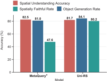
We tested the Spatial Reversal Curse using MetaQuery. As no public checkpoint is available, we train MetaQuery using the official implementation under the same experimental settings described in Section 5.1. As shown in Figure 2, MetaQuery achieves a high Spatial Understanding Accuracy (SUA) of 82.54%, which indicates that the model possesses sufficient perceptual capacity to recognize spatial layouts from remote sensing imagery in the understanding direction.
In contrast, when conditioned on equivalent textual instructions for text-to-image generation, the same model exhibits a pronounced degradation in spatial faithfulness. Although the target object is frequently synthesized, with an Object Generation Rate (OGR) of 80.95%, correct spatial placement is achieved in less than half of the cases, as reflected by a Spatially Faithful Rate (SFR) of 47.62%.
The discrepancy yields a substantial spatial gap of
indicating that generation failures predominantly stem from incorrect spatial execution rather than object hallucination or missing content.
To further examine the generality of this phenomenon beyond the MetaQuery-style paradigm, we additionally experiment with Show-o [Xie et al., 2025]. After fine-tuning Showo on remote sensing data, we observe a similar asymmetry, where ∆ reaches 27.78%. Detailed experimental settings and results for Show-o are provided in the supplementary materials.
4 Methodology
4.1 Model Architecture
We adopt a unified framework that bridges a multimodal large language model (MLLM) and a diffusion-based image generator through a set of learnable queries. As illustrated in Fig. 3, textual instructions are first processed by the MLLM, and the resulting query representations are transformed into conditioning signals that guide diffusion-based image synthesis. We adopt Qwen2.5-VL-3B [Bai et al., 2025b] as the multimodal large language model backbone and SANA-1.6B [Xie et al., 2024] as the diffusion-based image generator, bridged by N = 256 learnable queries and a 24-layer Transformerbased connector. This configuration follows the best practice of MetaQuery [Pan et al., 2025] and is fixed across all experiments.
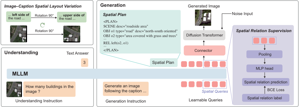
Within this unified framework, Uni-RS incorporates three complementary spatial mechanisms. Spatial-Layout Planning rewrites the input instruction into a structured spatial plan, which is attended by learnable queries to pass the spatial layout through to diffusion-based synthesis. Spatial-Aware Query Supervision further supervises a designated subset of learnable queries with spatial relation labels through an auxiliary prediction head. Image-Caption Spatial Layout Variation augments training with rotated image-caption pairs to strengthen the model's sensitivity to spatial layouts beyond object identity.
4.2 Spatial-Layout Planning
Remote sensing image generation often involves complex scenes with dense object distributions. In such cases, spatial layout constraints are easily overshadowed by long, objectcentric descriptions: object names correspond to salient visual patterns and receive strong supervision, whereas spatial relations are abstract and only implicitly learned through standard generative objectives.
To address this, we introduce Spatial-Layout Planning, which rewrites a user instruction into a structured layout specification expressed in text. Specifically, instead of conditioning on raw captions alone, the MLLM first generates a plan enclosed by a <PLAN> tag that decomposes the instruction into three structured components: the global scene context (SCENE), object instances with coarse spatial locations (OBJ), and explicitly stated spatial relations (REL), as illustrated in Figure 3. This structured plan makes spatial constraints-which are otherwise buried in free-form descriptions-directly visible to the learnable queries, encouraging them to better preserve the intended layout during image generation.
We note that, although Spatial-Layout Planning produces an auxiliary textual plan like chain-of-thought (CoT), its purpose differs fundamentally from CoT prompting: rather than explaining reasoning steps, the plan explicitly externalizes spatial layout information that is otherwise implicit in natural language instructions.
4.3 Spatial-Aware Query Supervision
The learnable queries serve as the primary carriers of conditioning information passed from the MLLM to the diffusion model. When rich language instructions are compressed into a fixed set of queries, fine-grained spatial cues may be attenuated. To mitigate this effect, we introduce a spatial-aware query supervision term: during training, a subset of queries, denoted as Qspa ⊂ Q, is softly biased to retain spatial relations that are explicitly mentioned in the instruction via an auxiliary supervision signal.
This supervision relies on a closed-set vocabulary of spatial relations that reflects how spatial concepts are expressed in remote sensing captions. Drawing on cognitive geography, we organize spatial expressions into five broad categories: directional, topological, distance-based, orientation-based, and distributional relations, with the last capturing characteristic multi-object arrangements in overhead imagery. Based on this taxonomy, we construct a spatial relation vocabulary V with K = 79 spatial relation labels, which provides coverage of spatial expressions appearing in the training corpus (see supplementary materials for the full spatial relation vocabulary).
Given an instruction, we extract the spatial relations it explicitly mentions to obtain a multi-hot target vector y ∈ {0, 1}K . During training, features from Qspa are aggregated (e.g., via mean pooling) and passed through a lightweight projection head to predict ˆy ∈ RK :
We supervise this prediction using a binary cross-entropy loss:
This auxiliary loss biases the spatial-aware queries to preserve instruction-level spatial cues that are subsequently reflected in the conditioning signals used for image generation. In our experiments, we designate the last 32 queries as Qspa, providing sufficient capacity to encode spatial relations, while preserving the remaining queries for modeling object semantics and other non-spatial information.
4.4 Image-Caption Spatial Layout Variation
Finally, we introduce Image-Caption Spatial Layout Variation as a geometry-aware training strategy. This design exploits a geometric property of overhead imagery: rotating a remote sensing image preserves scene semantics, object categories and attributes, as well as topological, distance-based, and distributional spatial relations, while resulting in systematic changes to absolute object locations and orientation- or direction-dependent spatial relations.
Concretely, for each training image, we generate rotated variants with angles θ ∈ {90◦ , 180◦ , 270◦ }. To maintain geometric consistency between vision and language, the associated caption is rewritten accordingly. Given a rotation angle θ, a large language model is prompted to identify spatial expressions in the original caption and update those that are direction- or orientation-dependent based on the corresponding geometric transformation (e.g., changing "North of" to "East of" for a 90◦ clockwise rotation), while preserving scene descriptions, object categories, attributes, and rotationinvariant spatial relations. The rewritten caption remains linguistically fluent and semantically aligned with the rotated image.
As a result, the training data contain paired image-caption instances that depict identical scenes and objects but differ in absolute object locations and orientation-sensitive spatial relations. This paired variation isolates spatial layout changes, enabling the model to associate spatial-related descriptions with geometric transformations instead of memorizing absolute object locations.
4.5 RS-Spatial: A Spatial Annotation Dataset for Training Uni-RS
To support the proposed spatial mechanisms in a unified and systematic manner, we construct a new large-scale spatial annotation dataset, termed RS-Spatial, built upon RSICap [Hu et al., 2025] and VRSBench [Li et al., 2024]. This dataset aims to provide additional spatial layout supervision for remote sensing text-to-image generation in unified models.
| Method | FID (↓) | Zero-Shot Cls-OA (↑) | CLIP (↑) |
|---|---|---|---|
| Attn-GAN | 95.81 | 32.56% | 20.19 |
| DAE-GAN | 93.15 | 29.74% | 19.69 |
| DF-GAN | 109.41 | 51.99% | 19.76 |
| Lafite | 74.11 | 49.37% | 22.52 |
| DALL-E | 191.93 | 28.59% | 20.13 |
| Txt2Img-MHNVQVAE | 175.36 | 41.46% | 21.35 |
| Txt2Img-MHNVQGAN | 102.44 | 65.72% | 20.27 |
| RSDiff | 66.49 | - | - |
| CRS-Diff | 50.72 | 69.31% | 20.33 |
| Text2Earth† | 67.92 | 57.74% | 23.91 |
| Text2Earth | 24.49 | 90.26% | 25.62 |
| Uni-RS (Ours)† | 46.83 | 66.93% | 24.11 |
| Uni-RS (Ours) | 22.11 | 91.63% | 25.68 |
| RSIEval | VRSBench | ||||
|---|---|---|---|---|---|
| Method | FID (↓) | SFR (↑) | CLIP (↑) | FID (↓) | CLIP (↑) |
| Text2Earth† | 17.07 | 63.40 | 23.74 | 8.28 | 24.85 |
| Text2Earth | 16.22 | 65.10 | 23.79 | 7.42 | 24.93 |
| Uni-RS (Ours) | 13.04 | 80.16 | 24.01 | 4.51 | 25.46 |
RS-Spatial contains three types of spatial annotations: (i) structured layout descriptions for Spatial-Layout Planning, (ii) spatial relation labels aligned with the predefined vocabulary for spatial-aware query supervision, and (iii) rewritten captions corresponding to rotated images for image-caption spatial layout variation. All annotations are generated using Qwen3-VL-235B-A22B-Instruct [Bai et al., 2025a] through a shared two-stage pipeline. In the first stage, the model is prompted to produce task-specific annotations for each image-caption pair. In the second stage, the same model verifies the consistency between the generated annotations and the original image-caption pairs or applied rotations, and samples that fail this verification are discarded. In total, RS-Spatial contains 20,496 structured spatial layout plans, 22,849 spatial relation annotations, and 36,702 rotationconsistent image-caption pairs.
Importantly, RS-Spatial introduces no new semantic content beyond what is explicitly supported by the original captions, ensuring that all spatial relations and layout elements are strictly text-faithful. As a result, the dataset provides a unified spatial supervision resource that supports spatial planning, spatial relation modeling, and rotation-based data augmentation within a single framework. The dataset will be publicly released.
| RSIEval | VRSBench-val | ||||||||||||
|---|---|---|---|---|---|---|---|---|---|---|---|---|---|
| Captioning | VQA | Captioning | VQA Avg | Grounding | |||||||||
| Method | B-4 | METEOR | R-L | CIDEr | Avg | Method | B-4 | METEOR | R-L | CIDEr | Acc@0.5 | Acc@0.7 | |
| BLIP2 | 0.0 | 3.4 | 11.6 | 0.1 | 45.6 | Mini-Gemini | 14.3 | 21.5 | 36.8 | 33.5 | 77.8 | 30.1 | 6.8 |
| MiniGPT4 | 17.3 | 19.9 | 35.3 | 16.3 | 21.8 | GeoChat | 13.8 | 21.1 | 35.2 | 28.2 | 76.0 | 49.8 | 19.9 |
| RSGPT | 22.1 | 23.6 | 41.7 | 31.4 | 65.2 | GeoPix | 14.0 | 23.4 | 36.3 | 31.3 | 74.9 | 49.8 | 20.0 |
| GeoPix† | 2.8 | 9.4 | 16.1 | 2.9 | 65.5 | LLaVA-1.5 | 14.7 | 21.9 | 36.9 | 33.9 | 76.4 | 41.6 | 13.6 |
| Ours | 16.8 | 20.9 | 38.8 | 22.3 | 65.4 | Ours | 12.2 | 20.7 | 34.6 | 30.0 | 74.0 | 45.7 | 13.3 |
5 Experiments
5.1 Experimental Setup
Training Protocol. We adopt a two-stage training protocol, in which Stage 1 optimizes only the text-to-image generation objective, whereas Stage 2 jointly optimizes both understanding and generation tasks.
Stage 1 (GenerationTraining). In the first stage, we freeze the MLLM and update only the Transformer connector and the diffusion backbone. The model is trained on Git10M [Liu et al., 2025a], a large-scale remote sensing image-text corpus containing approximately 10 million pairs. This stage focuses on text-to-image generation, enabling the diffusion backbone to internalize the visual characteristics of overhead imagery, including top-down viewpoints and remote-sensing-specific textures, thereby establishing a robust generative prior.
Stage 2 (Joint Understanding-Generation Training). In the second stage, we unfreeze the remaining trainable components while keeping the MLLM visual encoder (ViT) and the diffusion VAE fixed. We jointly optimize multimodal understanding objectives-including VQA, captioning, and grounding-together with text-to-image generation. Training data in this stage include RSICap [Hu et al., 2025], VRSBench [Li et al., 2024], and the proposed RS-Spatial dataset. RSICap and VRSBench are used for multimodal understanding, with their captions reused as prompts for text-to-image generation, while RS-Spatial provides spatial layout plans, spatial relation labels, and rotation-consistent image-caption pairs to support spatial planning, spatial relation modeling, and geometry-consistent data augmentation. Note that for spatial layout plans, we apply them to both understanding and generation training, enabling the model to learn not only to produce layout plans from language inputs, but also to utilize these plans for image synthesis.
Implementation Details. All models are trained using the AdamW optimizer with a batch size of 1024 on 8 NVIDIA A800 GPUs (80GB). Both training stages employ a cosine learning rate schedule with a 10% warmup phase. Stage 1 is trained for 10 epochs with an initial learning rate of 2×10⁻⁵ . Stage 2 is fine-tuned for 5 epochs with an initial learning rate of 1 × 10⁻⁵ . The balancing coefficient for the spatial supervision loss is set to λ = 0.1.
5.2 Comparison with SoTAModels
We compare Uni-RS with existing remote sensing text-toimage generation models on RSICD, RSIEval, and VRSBench.
Text-to-Image Generation on RSICD. Table 1 reports results on RSICD using FID, zero-shot classification accuracy (Cls-OA), and CLIP score. Following common practice in prior work, we report results under two settings: with RSICD fine-tuning, where Uni-RS is fine-tuned on the RSICD training set for five epochs before evaluation, and without RSICD fine-tuning.
As shown in Table 1, fine-tuning Uni-RS on RSICD leads to state-of-the-art performance across all three metrics. Notably, even without RSICD fine-tuning, Uni-RS outperforms Text2Earth and several prior methods that are explicitly finetuned on RSICD, such as CRS-Diff [Tang et al., 2024] and Txt2Img-MHN [Xu et al., 2023]. These results demonstrate strong text-to-image generation capability and generalization of Uni-RS, consistent with prior findings that enhanced multimodal understanding can benefit generation performance.
Spatial Faithful Generation on RSIEval and VRSBench. Table 2 reports results on RSIEval and VRSBench. Compared to RSICD, captions in RSIEval and VRSBench are longer and more structured, typically involving multiple objects and explicitly specified spatial relations. These characteristics make spatial layout adherence a central factor in evaluating generation quality. For a fair comparison with the prior state-of-the-art model Text2Earth, we further fine-tune Text2Earth on VRSBench and RSICap for 5 epochs using the same training protocol.
As shown in Table 2, Uni-RS outperforms the fine-tuned Text2Earth model across all metrics on both benchmarks. On RSIEval, Uni-RS reduces FID by approximately 20% compared to the fine-tuned Text2Earth model, while improving the Spatially Faithful Rate (SFR) by approximately 23%. On VRSBench, Uni-RS achieves a 39% reduction in FID and an approximately 2% increase in CLIP score. The pronounced improvement in SFR indicates that Uni-RS is not only capable of generating the target objects, but also places them in accordance with the layout specified in the caption.
Understanding Tasks. Table 3 reports results on image captioning, visual question answering, and visual grounding tasks. Across all three tasks, Uni-RS achieves performance comparable to existing remote sensing vision-language models, with minimal performance gaps on the reported metrics. These results demonstrate that Uni-RS functions as an effective unified model, exhibiting strong multimodal understanding while simultaneously supporting text-to-image generation.
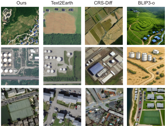
Qualitative Analysis. As shown in Figure 4, qualitative results further corroborate the quantitative findings. Generaldomain unified models are able to correctly identify intended objects, while they often fail to render the overhead perspective. In contrast, remote-sensing-specific generation models produce images with more realistic overhead appearances, but frequently struggle to faithfully follow the objects and to place them in spatial configurations consistent with the described layouts. By comparison, Uni-RS is able to consistently synthesize the objects described in the caption while simultaneously respecting their intended spatial arrangements.
5.3 Ablation Study
We perform an ablation study to evaluate the contribution of each proposed component. Results are reported in Table 4 on RSIEval and VRSBench. Overall, the ablation results show that all three components consistently improve spatial faithfulness, and their effects accumulate in a stable and complementary manner. Introducing spatial layout planning already leads to a clear gain in spatially faithful generation, while simultaneously improving image fidelity and semantic alignment, as reflected by reduced FID and higher CLIP scores. Image-caption spatial layout variation further strengthens this trend by exposing the model to geometry-consistent variations, yielding additional improvements in both spatial adherence and overall generation quality. In contrast, spatialaware query supervision primarily enhances spatial faithfulness by reinforcing instruction-level spatial constraints in the conditioning space, while having only a marginal impact on FID and CLIP. When combined, the three components progressively mitigate the Spatial Reversal Curse, achieving the highest spatial fidelity across benchmarks without degrading generation quality.
| VRSBench | RSIEval | ||||
|---|---|---|---|---|---|
| Method | FID | CLIP | FID | CLIP | SFR |
| Base | 4.91 | 25.33 | 13.47 | 23.70 | 47.62 |
| Base + SLP | 4.62 | 25.40 | 13.44 | 23.81 | 54.00 |
| Base + SLP + SQS | 4.64 | 25.42 | 13.33 | 23.79 | 63.49 |
| Base + SLP + SQS + ISV | 4.51 | 25.46 | 13.04 | 24.01 | 80.16 |
6 Conclusion
We presented Uni-RS, the first unified remote sensing visionlanguage model that systematically investigates and mitigates the Spatial Reversal Curse between understanding and generation. By introducing spatially explicit mechanisms through Spatial-Layout Planning and incorporating spatial supervision for latent queries, Uni-RS improves spatial faithfulness in text-to-image generation while preserving strong multimodal understanding. Extensive experiments across multiple benchmarks demonstrate that Uni-RS effectively integrates spatial understanding and spatial execution within a single unified framework.
Acknowledgements
We acknowledge the support of the National Natural Science Foundation of China (Grant Nos. 42430106 and 42401407) and the China Postdoctoral Science Foundation (Grant No. 2024M760086).
Contribution Statement
Weiyu Zhang and Yuan Hu contributed equally to this work. Yu Liu is the corresponding author.
@inproceedings{ijcai2026p231,
  title     = {Uni-RS: A Spatially Faithful Unified Understanding and Generation Model for Remote Sensing},
  author    = {Zhang, Weiyu and Hu, Yuan and Li, Yong and Liu, Yu},
  booktitle = {Proceedings of the Thirty-Fifth International Joint Conference on
               Artificial Intelligence, {IJCAI-26}},
  publisher = {International Joint Conferences on Artificial Intelligence Organization},
  editor    = {Diego Calvanese},
  pages     = {2073--2081},
  year      = {2026},
  month     = {8},
  note      = {Main Track},
  doi       = {10.24963/ijcai.2026/231},
  url       = {https://doi.org/10.24963/ijcai.2026/231},
}
TY - CPAPER TI - Uni-RS: A Spatially Faithful Unified Understanding and Generation Model for Remote Sensing AU - Zhang, Weiyu AU - Hu, Yuan AU - Li, Yong AU - Liu, Yu T2 - Proceedings of the Thirty-Fifth International Joint Conference on Artificial Intelligence, IJCAI-26 PB - International Joint Conferences on Artificial Intelligence Organization PY - 2026 SP - 2073 EP - 2081 DO - 10.24963/ijcai.2026/231 UR - https://doi.org/10.24963/ijcai.2026/231 ER -Copied
Machine-readable versions of this paper, for tools and AI agents: