AwakeForest: An Interactive Geospatial Platform for Large-Scale Forest Imagery
Proceedings of the Thirty-Fifth International Joint Conference on Artificial Intelligence. Demo Track. Pages 8487-8491.
https://doi.org/10.24963/ijcai.2026/986
Keywords
- AI: Multidisciplinary Topics and Applications
- AI: Natural Language Processing
- AI: Computer Vision
- AI: Knowledge Representation and Reasoning
Abstract
Forest imagery analysis often involves multiple tightly coupled vision tasks, which must be performed under substantial variation in geographic regions, sensors, and acquisition conditions. However, practitioners often lack a unified tool that is geospatial-native, cloud-optimized, and ML-integrated for end-to-end workflows spanning annotation, prediction, visualization, and downstream analysis at scale. We present AwakeForest, an interactive end-to-end platform designed for large-scale forest imagery that integrates model-assisted inference, automatic annotation, and human-in-the-loop refinement within a single workflow. Our platform supports plug-and-play integration of pretrained models and enables scalable interaction with forest imagery ranging from standard aerial scenes to large orthomosaics that can span several gigabytes to hundreds of gigabytes. AwakeForest produces analysis-ready outputs that can be directly used for downstream analysis and to support iterative model and annotation updates on new scenes. We demonstrate the system on the PALMS dataset and illustrate how AwakeForest supports an end-to-end workflow for practical forest management and analysis.
- [Amershi et al., 2014] Saleema Amershi, Maya Cakmak, W. Bradley Knox, and Todd Kulesza. Power to the peo- ple: The role of humans in interactive machine learning. AI Magazine, 35(4):105-120, 2014.
- [Banskota et al., 2014] Asim Banskota, Nilam Kayastha, Michael J. Falkowski, et al. Forest monitoring using land- sat time series data: A review. Canadian Journal of Re- mote Sensing, 40(5):362-384, 2014.
- [Camalan et al., 2022] Seda Camalan, Kangning Cui, Vic- tor Paul Pauca, et al. Change detection of amazonian al- luvial gold mining using deep learning and sentinel-2 im- agery. Remote Sensing, 14(7):1746, 2022.
- [Carion et al., 2026] Nicolas Carion, Laura Gustafson, et al. SAM 3: Segment anything with concepts. In International Conference on Learning Representations, 2026.
- [Community, 2023] Cloud Optimized GeoTIFF Commu- nity. Cloud Optimized GeoTIFF. https://www.ogc.org/ standards/geotiff, 2023. Link
- [Cui et al., 2025a] Kangning Cui, Wei Tang, Rongkun Zhu, et al. Efficient localization and spatial distribution mod- eling of canopy palms using uav imagery. IEEE Transac- tions on Geoscience and Remote Sensing, 2025.
- [Cui et al., 2025b] Kangning Cui, Rongkun Zhu, et al. De- tection and geographic localization of natural objects in the wild: A case study on palms. In International Joint Conference on Artificial Intelligence, 2025. IJCAI
- [CVAT.ai Corp., 2023] CVAT.ai Corp. Computer Vision An- notation Tool. https://github.com/cvat-ai/cvat, 2023. Link
- [de Almeida et al., 2025] Danilo RA de Almeida, Laura B Vedovato, et al. Remote sensing approaches to moni- tor tropical forest restoration: Current methods and future possibilities. Journal of Applied Ecology, 2025. [DevelopmentSeed, 2025] DevelopmentSeed. TiTiler. https: //github.com/developmentseed/titiler, 2025. Link
- [Fails and Olsen, 2003] Jerry Alan Fails and Dan R. Olsen. Interactive machine learning. In Proceedings of the 8th In- ternational Conference on Intelligent User Interfaces (IUI '03), pages 39-45. ACM, 2003.
- [Gorelick and others, 2017] Noel Gorelick et al. Google earth engine: Planetary-scale geospatial analysis for ev- eryone. Remote Sensing of Environment, 202:18-27, 2017.
- [Hansen et al., 2013] M. C. Hansen, P. V. Potapov, et al. High-resolution global maps of 21st-century forest cover change. Science, 342(6160):850-853, 2013.
- [Jocher et al., 2023] Glenn Jocher, Jing Qiu, and Ayush Chaurasia. Ultralytics YOLO, January 2023. [Leaflet Contributors, 2023] Leaflet Contributors. Leaflet. https://github.com/Leaflet/Leaflet, 2023. Link
- [Lefsky et al., 2002] Michael A. Lefsky, Warren B. Cohen, David J. Harding, Geoffrey G. Parker, Steven A. Acker, and S. Thomas Gower. Lidar remote sensing of above- ground biomass in three biomes. Global Ecology and Bio- geography, 11(5):393-399, 2002.
- [Ma et al., 2022] Zaiyang Ma, Min Chen, Zhong Zheng, et al. Customizable process design for collaborative geographic analysis. GIScience & Remote Sensing, 59(1):914-935, 2022.
- [MinIO Inc., 2025] MinIO Inc. MinIO Object Storage. https: //github.com/minio/minio, 2025. Link
- [Nguyen, 2025] Viet Anh Nguyen. AnyLabeling -Effort- less data labeling with AI support. https://github.com/ vietanhdev/anylabeling, 2025. Link
- [Palomino et al., 2017] Jenny Palomino, Oliver C Muellerklein, and Maggi Kelly. A review of the emergent ecosystem of collaborative geospatial tools for addressing environmental challenges. Computers, Environment and Urban Systems, 65:79-92, 2017.
- [QGIS Development Team, 2026] QGIS Develop- ment Team. Qgis geographic information system. https://www.qgis.org, 2026. Link
- [Quiñonero-Candela et al., 2008] Joaquin Quiñonero- Candela, Masashi Sugiyama, Anton Schwaighofer, and Neil D. Lawrence, editors. Dataset Shift in Machine Learning. The MIT Press, Cambridge, MA, 2008.
- [Ramírez, 2024] Sebastián Ramírez. FastAPI. https://fastapi. tiangolo.com, 2024. Link
- [Ravi et al., 2025] Nikhila Ravi, Valentin Gabeur, et al. Sam 2: Segment anything in images and videos. In Interna- tional Conference on Learning Representations, 2025.
- [Redmon et al., 2016] Joseph Redmon, Santosh Divvala, Ross Girshick, and Ali Farhadi. You only look once: Uni- fied, real-time object detection. In IEEE/CVF Conference on Computer Vision and Pattern Recognition, pages 779- 788, 2016.
- [Refractions Research, 2024] Refractions Research. Post- GIS. https://postgis.net, 2024. Link
- [Supabase Inc., 2026] Supabase Inc. Supabase. https:// supabase.com, 2026. Link
- [Tkachenko et al., 2020] Maxim Tkachenko, Mikhail Ma- lyuk, Andrey Holmanyuk, and Nikolai Liubimov. La- bel Studio: Data labeling software. https://github.com/ HumanSignal/label-studio, 2020. Link
- [Tuia et al., 2016] Devis Tuia, Claudio Persello, and Lorenzo Bruzzone. Domain adaptation for the clas- sification of remote sensing data: An overview of recent advances. IEEE Geoscience and Remote Sensing Magazine, 4(2):41-57, 2016.
- [Zhu et al., 2026] Rongkun Zhu, Kangning Cui, et al. From orthomosaics to raw uav imagery: Enhancing palm de- tection and crown-center localization. International Geo- science and Remote Sensing Symposium, 2026.
References were extracted automatically from the PDF and may contain errors.
Full text extracted automatically from the PDF; figures, tables and equations may differ. The PDF is the version of record.
1 Introduction
Forest imagery analysis commonly requires multiple vision tasks, including object detection, spatial delineation, and quantitative analysis, for ecological monitoring and forest management [Camalan et al., 2022; de Almeida et al., 2025; Cui et al., 2025a]. In practice, these tasks are tightly coupled and need to be conducted within a single workflow. However, constructing high-quality labeled datasets is costly, and domain shifts across regions, sensors, and acquisition conditions further limit the reuse of existing annotations and models. As a result, practitioners often need to repeatedly adapt models and rebuild datasets with limited integrated tooling.
Several existing platforms support model-assisted labeling and integration of pretrained models. Tools such as CVAT [CVAT.ai Corp., 2023], AnyLabeling [Nguyen, 2025], and Label Studio [Tkachenko et al., 2020] allow users to load detection or segmentation models to assist manual annotation and are effective for generic object annotation workflows and conventional computer vision datasets. However, they are not specifically designed for forest and ecological analysis, where imagery is often high-resolution and spatially extensive. In many scenarios, ecologists work with large orthomosaic images produced by automated reconstruction pipelines, where a single image can range from several to hundreds of gigabytes and objects of interest may be small and densely distributed. In these settings, annotation is tightly coupled with analysis, requiring iterative integration of detection, segmentation, counting, and domain-driven refinement rather than treating labeling as a standalone preprocessing step.
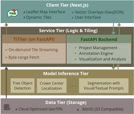
AwakeForest is built to address this gap by focusing particularly on large-scale forest imagery and practical forest management. We provide a unified interactive design (Figure 1) that integrates automated predictions with human-inthe-loop refinement, allowing results to be reused for downstream analysis or model adaptation across multiple tasks.
2 SystemOverview
2.1 High-Level SystemArchitecture
AwakeForest adopts a modular, service-oriented architecture that separates user interaction, workflow coordination, model inference, and data management (see Figure 1). This separation allows system components to evolve independently while maintaining a coherent end-to-end workflow.
The client tier provides a user interface for managing datasets, models, and projects. Users can register datasets by specifying object storage endpoints and bucket details, add detection or segmentation models hosted locally or remotely by providing API endpoints, and create projects that link datasets with models. The service tier serves as a central coordinator responsible for user authentication, project organization, annotation management, and orchestration of inference requests across tasks. The model inference tier consists of independent services registered by users through model endpoints and task type specifications. The data tier serves large datasets through scalable object storage with ondemand tile streaming, separating raw imagery from spatial metadata and annotations to support interactive analysis.
2.2 Integrated Geospatial AnnotationWorkflow
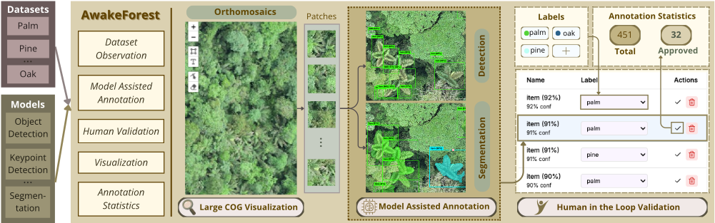
AwakeForest organizes forest imagery analysis through a project-based structure that links geospatial datasets with external model services for interactive annotation, as shown in Figure 2. Each project connects a dataset with the registered models and provides two complementary views of the data.
The global view displays the entire orthomosaic, allowing users to navigate with pan and zoom controls while viewing annotation overlays for spatial context and progress tracking across large forest scenes in real time. The patch-level annotation view divides the dataset into fixed-size image patches where users can select models from a drop-down menu to generate predictions on the current patch; manually select and annotate objects missed by the models; assign labels and verify annotations for quality control and consistency; and navigate between patches to systematically annotate the dataset.
To ensure consistency across automated predictions and user edits, AwakeForest maintains a unified internal representation of intermediate results based on geospatial coordinates. By decoupling annotations from specific image tiles and patch boundaries, objects of interest are stored with absolute spatial attributes and standardized geometry formats. This design supports stable indexing, cross-model comparison, and incremental updates during refinement. It allows annotations to be managed and overlaid independently across diverse datasets or imagery sources with different resolutions, enabling outputs from various models to be combined, inspected, and refined within a cohesive spatial context.
2.3 Implementation Details
The platform is implemented using Next.js [Vercel Inc., 2026] for the client tier and FastAPI [Ram´ırez, 2024] for the service tier, with Leaflet [Leaflet Contributors, 2023] providing interactive geospatial map visualization. Data persistence and operations are managed through Supabase [Supabase Inc., 2026], which provides spatial indexing via PostGIS (a PostgreSQL extension for geospatial queries) [Refractions Research, 2024] and JWT-based authentication (JSON Web Tokens for secure, stateless session management).
Cloud Optimized GeoTIFFs (COGs) [Community, 2023] are stored in MinIO [MinIO Inc., 2025] object storage and served through dynamic tiling via TiTiler [DevelopmentSeed, 2025] integration. The service tier handles on-demand tile generation based on client viewport requests, enabling efficient streaming of image data at the scale required for interactive exploration of large datasets without preprocessing.
Model inference services are registered as external FastAPI endpoints defined by task type, such as detection or segmentation. This approach allows the platform to invoke remote inference during patch-level annotation without coupling inference logic to the core application. The architecture supports integration of various vision models including YOLO [Redmon et al., 2016; Jocher et al., 2023] detectors and SAM [Ravi et al., 2025; Carion et al., 2026] models for object detection, segmentation, and automatic labeling tasks.
| Tool | Geospatial Native | Spatial Indexing | Cloud Optimized | AI-Assisted Labeling |
|---|---|---|---|---|
| Label Studio | × | × | × | ✓ |
| CVAT | × | × | × | ✓ |
| AnyLabeling | × | × | × | ✓ |
| QGIS | ✓ | ✓ | ✓ | × |
| AwakeForest | ✓ | ✓ | ✓ | ✓ |
2.4 Comparison with Existing Tools
Existing annotation tools such as Label Studio, AnyLabeling, and CVAT support generic image-centric labeling with optional AI-assisted proposals, but they do not treat geospatial coordinates and large orthomosaics as first-class primitives. Conversely, geographic information system (GIS) platforms such as QGIS [QGIS Development Team, 2026] are geospatial-native environments designed for spatial data management, indexing, and map-based analysis, yet they lack an integrated interactive ML annotation workflow with plugand-play model inference capabilities. AwakeForest combines geospatial-first data management, cloud-optimized orthomosaic access, and model-integrated interactive labeling within a unified system architecture and workflow (Table 1).
3 InteractiveWorkflow and Demonstration
We show the capabilities of AwakeForest on the PALMS dataset [Cui et al., 2025b], which provides a realistic case for interactive forest imagery analysis at scale. PALMS consists of high-resolution UAV-derived orthomosaics covering large, spatially continuous forest regions with dense and heterogeneous canopy structure. These characteristics require joint handling of labeling, object detection and localization, segmentation, and spatial reasoning, which are well suited for illustrating how AwakeForest supports end-to-end interaction from initial inference to refined, analysis-ready results.
Within AwakeForest, PALMS is loaded as large orthomosaics and interactively explored at multiple spatial scales. Users first identify regions of interest corresponding to forest patches or survey areas and initiate object searching using pretrained detection models. These models generate initial proposals for palm instances, including bounding boxes and candidate crown centers. Optionally, users can invoke SAMbased segmentation using these predicted boxes as prompts to obtain high-resolution instance masks for each detected palm. This enables quick conversion from coarse localization to detailed crown delineation without manual mask drawing.
Users can also invoke prompt-based segmentation for automatic labeling using either bounding boxes or text prompts. For PALMS, text prompts such as "palm" or "palm tree" can be used to retrieve candidate instances and generate corresponding masks for rapid initialization. With box prompts, the system produces a mask for the specified region and leverages the few-shot capability of SAM3 to suggest additional masks for visually similar crowns beyond the initial box. This interaction supports rapid discovery and correction of missed instances and boundary errors, reducing the need for manual annotation from scratch and improving overall efficiency.
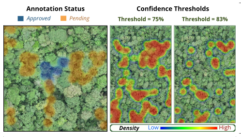
Throughout the demonstration, automated predictions and user refinements are maintained within a single project context. Verified results can be promoted to finalized annotations, while intermediate predictions remain traceable to their originating models. Figure 3 summarizes the analysis-ready outcomes at the orthomosaic level, combining verification status with confidence-thresholded prediction densities. Users can filter predictions by confidence, and the retained instance locations are summarized via kernel density estimation to reveal spatial clusters and coverage patterns. The finalized outputs are then used to derive spatial summaries such as palm center distributions and instance counts over selected regions [Cui et al., 2025a; Zhu et al., 2026].
4 Discussion and Conclusion
AwakeForest is an interactive platform that integrates model-assisted inference with human-in-the-loop refinement for large-scale forest imagery analysis. As a workfloworiented platform, the quality of intermediate and final results depends on the suitability of the employed pretrained models, particularly under substantial domain shift or visually complex forest conditions, where additional user refinement may be required [Tuia et al., 2016; Qui˜nonero-Candela et al., 2008]. Interactive analysis over very large orthomosaics also entails practical computational considerations [Fails and Olsen, 2003; Amershi et al., 2014], such as inference latency and visualization overhead, which are inherent to large-scale geospatial data processing [Gorelick and others, 2017].
This work focuses on demonstrating the platform on RGB forest imagery in a representative forest management scenario and does not aim to provide quantitative benchmarks on predictive accuracy or annotation efficiency. Extensions to additional sensing modalities, including multispectral imagery [Hansen et al., 2013], LiDAR [Lefsky et al., 2002], and temporal data [Banskota et al., 2014], as well as collaborative and multi-user workflows [Palomino et al., 2017; Ma et al., 2022], are left as future work. Within its current scope, AwakeForest illustrates how an integrated, endto-end workflow can support detection, segmentation, spatial summarization, and iterative refinement in a unified environment for practical forest monitoring and analysis.
Acknowledgments
We thank the reviewers for their constructive feedback. We also thank the Center for Amazonian Scientific Innovation (CINCIA) for providing access to the data used in this work. The project source code is available at https://github.com/ spygaurad/AwakeForest, and the demonstration video can be viewed at https://youtu.be/Z0EZj1PPDv4.
Contribution Statement
Suraj Prasai and Kangning Cui contributed equally to this work. Fan Yang served as the corresponding author.
@inproceedings{ijcai2026p986,
  title     = {AwakeForest: An Interactive Geospatial Platform for Large-Scale Forest Imagery},
  author    = {Prasai, Suraj and Cui, Kangning and Zhu, Rongkun and Alqahtani, Sarra and Zhang, Ying and Pauca, Victor Paúl and Silman, Miles R. and Yang, Fan},
  booktitle = {Proceedings of the Thirty-Fifth International Joint Conference on
               Artificial Intelligence, {IJCAI-26}},
  publisher = {International Joint Conferences on Artificial Intelligence Organization},
  editor    = {Diego Calvanese},
  pages     = {8487--8491},
  year      = {2026},
  month     = {8},
  note      = {Demo Track},
  doi       = {10.24963/ijcai.2026/986},
  url       = {https://doi.org/10.24963/ijcai.2026/986},
}
TY - CPAPER TI - AwakeForest: An Interactive Geospatial Platform for Large-Scale Forest Imagery AU - Prasai, Suraj AU - Cui, Kangning AU - Zhu, Rongkun AU - Alqahtani, Sarra AU - Zhang, Ying AU - Pauca, Victor Paúl AU - Silman, Miles R. AU - Yang, Fan T2 - Proceedings of the Thirty-Fifth International Joint Conference on Artificial Intelligence, IJCAI-26 PB - International Joint Conferences on Artificial Intelligence Organization PY - 2026 SP - 8487 EP - 8491 DO - 10.24963/ijcai.2026/986 UR - https://doi.org/10.24963/ijcai.2026/986 ER -Copied
Machine-readable versions of this paper, for tools and AI agents: