From Pixels to Progress: Generating Road Network from Satellite Imagery for Socioeconomic Insights in Impoverished Areas
Proceedings of the Thirty-Third International Joint Conference on Artificial Intelligence. AI for Good. Pages 7509-7517.
https://doi.org/10.24963/ijcai.2024/831
Keywords
- Humans and AI: General
- Data Mining: General
- Multidisciplinary Topics and Applications: General
- Computer Vision: General
- Machine Learning: General
Abstract
The Sustainable Development Goals (SDGs) aim to resolve societal challenges, such as eradicating poverty and improving the lives of vulnerable populations in impoverished areas. Those areas rely on road infrastructure construction to promote accessibility and economic development. Although publicly available data like OpenStreetMap is available to monitor road status, data completeness in impoverished areas is limited. Meanwhile, the development of deep learning techniques and satellite imagery shows excellent potential for earth monitoring. To tackle the challenge of road network assessment in impoverished areas, we develop a systematic road extraction framework combining an encoder-decoder architecture and morphological operations on satellite imagery, offering an integrated workflow for interdisciplinary researchers. Extensive experiments of road network extraction on real-world data in impoverished regions achieve a 42.7% enhancement in the F1-score over the baseline methods and reconstruct about 80% of the actual roads. We also propose a comprehensive road network dataset covering approximately 794,178 km2 area and 17.048 million people in 382 impoverished counties in China. The generated dataset is further utilized to conduct socioeconomic analysis in impoverished counties, showing that road network construction positively impacts regional economic development. The technical appendix, code, and generated dataset can be found at https://github.com/tsinghua-fib-lab/Road_network_extraction_impoverished_counties.
- [Abadie, 2005] Alberto Abadie. Semiparametric difference- in-differences estimators. The review of economic studies, 72(1):1-19, 2005.
- [Aguilar and Buchin, 2021] Jordi Aguilar and Kevin Buchin. Graph sampling for map comparison. In 3rd ACM SIGSPATIAL International Workshop on Spatial Gems, 2021.
- [Alagic, 2017] Arijan Alagic. An analysis of the causal re- lationship between transportation and gdp: A time-series approach for the united states. Major themes in economics, 19(1):17-37, 2017.
- [Anbao and Danhua, 2011] Tang Anbao and Zhao Danhua. A comparative analysis on the factors promoting china's economic growth based on demand. Energy Procedia, 5:1388-1393, 2011.
- [Banerjee et al., 2020] Abhijit Banerjee, Esther Duflo, and Nancy Qian. On the road: Access to transportation in- frastructure and economic growth in china. Journal of De- velopment Economics, 145:102442, 2020.
- [Bansal et al., 2016] Raghav Bansal, Gaurav Raj, and Tanupriya Choudhury. Blur image detection using lapla- cian operator and open-cv. In 2016 International Confer- ence System Modeling & Advancement in Research Trends (SMART), pages 63-67. IEEE, 2016.
- [Bettencourt, 2013] Luís MA Bettencourt. The origins of scaling in cities. science, 340(6139):1438-1441, 2013.
- [Biagioni and Eriksson, 2012] James Biagioni and Jakob Eriksson. Inferring road maps from global positioning system traces: Survey and comparative evaluation. Trans- portation research record, 2291(1):61-71, 2012.
- [Chen et al., 2023] Zhe Chen, Yuchen Duan, Wenhai Wang, Junjun He, Tong Lu, Jifeng Dai, and Yu Qiao. Vi- sion Transformer Adapter for Dense Predictions. In The Eleventh International Conference on Learning Represen- tations, 2023.
- [GaryBikini, 2023] GaryBikini. China administrative divi- sion shp, 2023.
- Geofabrik GmbH, OSM Foundation & Contributors. Ge- ofabrik downloads. http://download.geofabrik.de/ north-america/us.html, 2022. Accessed: 2023-10-30. Link
- [Gonzales and Wintz, 1987] Rafael C Gonzales and Paul Wintz. Digital image processing. Addison-Wesley Long- man Publishing Co., Inc., 1987.
- [Haklay and Weber, 2008] Mordechai Haklay and Patrick Weber. Openstreetmap: User-generated street maps. IEEE Pervasive computing, 7(4):12-18, 2008.
- [He et al., 2010] Kaiming He, Jian Sun, and Xiaoou Tang. Single image haze removal using dark channel prior. IEEE transactions on pattern analysis and machine intelligence, 33(12):2341-2353, 2010.
- [Ighodaro, 2009] C Ighodaro. Transport infrastructure and economic growth in nigeria. Journal of research in na- tional development, 7(2), 2009.
- [Lewis-Beck and Lewis-Beck, 2015] Colin Lewis-Beck and Michael Lewis-Beck. Applied regression: An introduc- tion, volume 22. Sage publications, 2015.
- [Li et al., 2022] Jiawei Li, Linkun Lyu, Jia Shi, Jie Zhao, Junjie Xu, Jiuchong Gao, Renqing He, and Zhizhao Sun. Generating community road network from gps trajectories via style transfer. In Proceedings of the 30th International Conference on Advances in Geographic Information Sys- tems, pages 1-4, 2022.
- [Liu et al., 2018] Yahui Liu, Jian Yao, Xiaohu Lu, Menghan Xia, Xingbo Wang, and Yuan Liu. Roadnet: Learning to comprehensively analyze road networks in complex ur- ban scenes from high-resolution remotely sensed images. IEEE Transactions on Geoscience and Remote Sensing, 57(4):2043-2056, 2018.
- [Mei et al., 2021] Jie Mei, Rou-Jing Li, Wang Gao, and Ming-Ming Cheng. CoANet: Connectivity attention net- work for road extraction from satellite imagery. IEEE Transactions on Image Processing, 30:8540-8552, 2021.
- [Mei, 2021] Jie Mei. CoANet: Connectivity attention net- work for road extraction from satellite imagery github page. https://github.com/mj129/CoANet, 2021. Link
- [Mnih and Hinton, 2010] Volodymyr Mnih and Geoffrey E Hinton. Learning to detect roads in high-resolution aerial images. In Computer Vision-ECCV 2010: 11th Euro- pean Conference on Computer Vision, Heraklion, Crete, Greece, September 5-11, 2010, Proceedings, Part VI 11, pages 210-223. Springer, 2010.
- [Mnih, 2013] Volodymyr Mnih. Machine learning for aerial image labeling. University of Toronto (Canada), 2013.
- [Nachmany and Alemohammad, 2019] Yoni Nachmany and Hamed Alemohammad. Detecting roads from satellite imagery in the developing world. In Proceedings of the IEEE/CVF Conference on Computer Vision and Pattern Recognition (CVPR) Workshops, June 2019.
- [Nath, 2016] DK Nath. Making cities and human settlements inclusive, safe, resilient and sustainable, sl: Sustainable urbanization summit. 2016.
- [Porta et al., 2009] Sergio Porta, Emanuele Strano, Valentino Iacoviello, Roberto Messora, Vito Latora, Alessio Cardillo, Fahui Wang, and Salvatore Scellato. Street centrality and densities of retail and services in bologna, italy. Environment and Planning B: Planning and design, 36(3):450-465, 2009.
- [Pradhan and Bagchi, 2013] Rudra P Pradhan and Tapan P Bagchi. Effect of transportation infrastructure on eco- nomic growth in india: The vecm approach. Research in Transportation economics, 38(1):139-148, 2013.
- [Ratledge et al., 2022] Nathan Ratledge, Gabe Cadamuro, Brandon de la Cuesta, Matthieu Stigler, and Marshall Burke. Using machine learning to assess the livelihood impact of electricity access. Nature, 611(7936):491-495, 2022.
- [Ruan et al., 2020] Sijie Ruan, Cheng Long, Jie Bao, Chun- yang Li, Zisheng Yu, Ruiyuan Li, Yuxuan Liang, Tianfu He, and Yu Zheng. Learning to generate maps from trajec- tories. In Proceedings of the AAAI conference on artificial intelligence, volume 34, pages 890-897, 2020.
- [Sebayang and Sebayang, 2020] Asnita Frida Sebayang and Lesta Karolina Sebayang. Infrastructure investment and its impact to regional development. Economics Development Analysis Journal, 9(3):269-280, 2020.
- [Shi et al., 2009] Wenhuan Shi, Shuhan Shen, and Yuncai Liu. Automatic generation of road network map from massive gps, vehicle trajectories. In 2009 12th interna- tional IEEE conference on intelligent transportation sys- tems, pages 1-6. IEEE, 2009.
- [Spadon et al., 2018] Gabriel Spadon, Gabriel Gimenes, and Jose F Rodrigues. Topological street-network characteri- zation through feature-vector and cluster analysis. In Com- putational Science-ICCS 2018: 18th International Con- ference, Wuxi, China, June 11-13, 2018, Proceedings, Part I 18, pages 274-287. Springer, 2018.
- [The National Rural Revitalization Administration, 2014] The National Rural Revitalization Administration. List of 832 impoverished counties nationwide. https://nrra.gov.cn/art/2014/12/23/art 343 981.html, 2014. Link
- [UN General Assembly, 2015] UN General Assembly. Transforming our world: the 2030 agenda for sustainable development. United Nations: New York, NY, USA, 2015.
- [UN System Chief Executives Board for Coordination, 2017] UN System Chief Executives Board for Coordina- tion. Leaving no one behind: Equality and non- discrimination at the heart of sustainable development. https://unsceb.org/sites/default/files/imported files/CEB% 20equality%20framework-A4-web-rev3.pdf, 2017. Link
- [Van Etten et al., 2018] Adam Van Etten, Dave Linden- baum, and Todd M Bacastow. Spacenet: A remote sensing dataset and challenge series. arXiv preprint arXiv:1807.01232, 2018.
- [Vargas-Munoz et al., 2020] John E Vargas-Munoz, Shiv- angi Srivastava, Devis Tuia, and Alexandre X Falcao. Openstreetmap: Challenges and opportunities in machine learning and remote sensing. IEEE Geoscience and Re- mote Sensing Magazine, 9(1):184-199, 2020.
- [Wang et al., 2021] Junjue Wang, Zhuo Zheng, Ailong Ma, Xiaoyan Lu, and Yanfei Zhong. Loveda: A remote sensing land-cover dataset for domain adaptive semantic segmen- tation. In J. Vanschoren and S. Yeung, editors, Proceed- ings of the Neural Information Processing Systems Track on Datasets and Benchmarks, volume 1. Curran, 2021.
- [Wang et al., 2023] Zhaohua Wang, Bin Lu, Bo Wang, Yueming Qiu, Han Shi, Bin Zhang, Jingyun Li, Hao Li, and Wenhui Zhao. Incentive based emergency demand response effectively reduces peak load during heatwave without harm to vulnerable groups. Nature Communica- tions, 14(1):6202, 2023.
- [Wegner et al., 2015] Jan Dirk Wegner, Javier Alexander Montoya-Zegarra, and Konrad Schindler. Road networks as collections of minimum cost paths. ISPRS Journal of Photogrammetry and Remote Sensing, 108:128-137, 2015.
- [Xi et al., 2023] Yanxin Xi, Yu Liu, Tong Li, Jingtao Ding, Yunke Zhang, Sasu Tarkoma, Yong Li, and Pan Hui. A satellite imagery dataset for long-term sustainable devel- opment in united states cities. Scientific data, 10(1):866, 2023.
- [Yang et al., 2022] Zhigang Yang, Daoxiang Zhou, Ying Yang, Jiapeng Zhang, and Zehua Chen. Road extraction from satellite imagery by road context and full-stage fea- ture. IEEE Geoscience and Remote Sensing Letters, 20:1- 5, 2022.
- [Zhang and Cheng, 2023] Yijia Zhang and Lu Cheng. The role of transport infrastructure in economic growth: Em- pirical evidence in the uk. Transport Policy, 133:223-233, 2023.
- [Zhang and Suen, 1984] Tongjie Y Zhang and Ching Y. Suen. A fast parallel algorithm for thinning digital pat- terns. Communications of the ACM, 27(3):236-239, 1984.
- [Zhang et al., 2018] Zhengxin Zhang, Qingjie Liu, and Yun- hong Wang. Road extraction by deep residual u-net. IEEE Geoscience and Remote Sensing Letters, 15(5):749-753, 2018.
- [Zhang et al., 2021] Jinrui Zhang, Ruilian Zhang, Junzhuo Xu, Jie Wang, and Guoqing Shi. Infrastructure investment and regional economic growth: Evidence from yangtze river economic zone. Land, 10(3):320, 2021.
- [Zhang et al., 2024] Xin Zhang, Yu Liu, Yuming Lin, Qing- min Liao, and Yong Li. Uv-sam: Adapting segment any- thing model for urban village identification. In Proceed- ings of the AAAI Conference on Artificial Intelligence, vol- ume 38, pages 22520-22528, 2024.
- [Zhou and Lin, 2019] Qi Zhou and Hao Lin. Investigating the completeness and omission roads of openstreetmap data in hubei, china by comparing with street map and street view. arXiv preprint arXiv:1909.04323, 2019.
- [Zhou et al., 2022] Yang Zhou, Chunyang Tong, and Yong- sheng Wang. Road construction, economic growth, and poverty alleviation in china. Growth and Change, 53(3):1306-1332, 2022.
References were extracted automatically from the PDF and may contain errors.
Full text extracted automatically from the PDF; figures, tables and equations may differ. The PDF is the version of record.
1 Introduction
Vulnerable populations in impoverished regions (e.g., poor areas distant from cities) encompass groups experiencing risks due to socioeconomic, health, or environmental factors [Wang et al., 2023]. Prioritizing resolving the societal challenges for vulnerable populations is crucial for achieving Sustainable Development Goals (SDGs) [UN General Assembly, 2015; Nath, 2016] and Leave No One Behind (LNOB) [UN
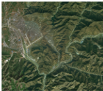
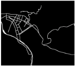
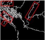
Figure 1: Comparison of (a) one satellite image, (b) corresponding OSM road network, and (c) our generated road network. (Latitude=33.6945◦N, Longitude=110.3237◦E). The roads in red rectangles in figure (c) are missing in OSM data.
System Chief Executives Board for Coordination, 2017]. As a Chinese saying goes, "If you want to be wealthy, build roads first.", to improve the living quality for people and boost the economic development in impoverished regions, the transportation infrastructure development, which facilitates internal transportation and attracts external investments, has been proved effective [Sebayang and Sebayang, 2020; Zhang et al., 2021; Banerjee et al., 2020]. Therefore, timely and accurate monitoring of road network development is essential for reducing the population left behind because of the vulnerabilities.
However, the current road network data in impoverished regions has several limitations. First, the commonly used OpenStreetMap (OSM) data exhibits significant deficiencies. OSM is a volunteered geographic information platform whose completeness relies on the annotations from volunteer contributors [Haklay and Weber, 2008; Vargas-Munoz et al., 2020; Zhou and Lin, 2019]. For example, Figure 1 shows an area in Danfeng County in Shaanxi Province, China, and its corresponding OSM and our produced road network. We can see that within the populated areas, some short connecting roads and certain major roads that link town centers of external areas through mountains are missing in OSM data. Second, the road data from official agencies covers roughly coarse-level survey data, possesses a time lag, and merely provides road length information, which prohibits interdisciplinary data users from accessing real-time and detailed road data. At last, purchasing road data from map platform corporations is unaffordable for most researchers and organizations. Those shortcomings hinder real-time road monitoring, especially in impoverished counties.
Meanwhile, various deep learning approaches for segmentation based on satellite imagery have recently been proposed [Yang et al., 2022; Mei et al., 2021; Zhang et al., 2018; Zhang et al., 2024]. Combined with the development of large-scale road annotation datasets [Van Etten et al., 2018; Mnih, 2013; Wang et al., 2021], the segmentation approaches recognize roads from satellite imagery. Approved by the advantages of long temporal spanning, comprehensive spatial coverage, and high spatial resolution, the widely used satellite imagery is a better data source for observing roads in impoverished regions with high accuracy [Mei et al., 2021; Xi et al., 2023; Nachmany and Alemohammad, 2019].
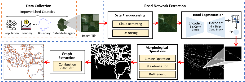
We propose a systematic framework for extracting road networks in impoverished regions from satellite imagery. Specifically, the framework consists of the data preprocessing, road segmentation, image morphological operations, and graph extraction steps. (1) The data pre-processing step adopts the Laplacian variance [Bansal et al., 2016] and pixel intensity [He et al., 2010] metric to filter out the invalid data in the satellite images. (2) Considering the occlusion in roads in satellite imagery, we use an encoder-decoder-based road extraction model including strip convolution and connectivity attention in the road segmentation step. (3) The image morphological operations include the morphological closing operation and skeletonization to transform the road mask into the road centerline binary image. (4) A combustion algorithm is applied in the graph extraction step to generate the road network graph with nodes and edges from the road centerline image. We evaluate our designed framework on satellite imagery and real-world road network data in impoverished counties in China. Besides, we propose a comprehensive road network dataset in 382 impoverished counties.
The main contributions of this work are summarized as follows:
- We propose a scalable framework for extracting countylevel road networks from satellite imagery in impoverished counties. We introduce statistical methods to filter irregular satellite imagery, and leverage an encoderdecoder architecture preserving road connectivity to segment road masks from satellite imagery. Through morphological operations and combustion algorithm, the county-level road network data is generated.
- To the best of our knowledge, we are the first to produce a fine-grained road network dataset covering 17.048 million people in 382 impoverished counties in China. The dataset will be beneficial for further SDG research about road infrastructure.
- Extensive experiments on real-world road data generation in impoverished counties show that our proposed framework achieves a 42.7% increase in F1-score compared with baselines and road length reconstruction rate of about 80%. We also conduct socioeconomic analysis on our produced road network dataset. The analysis shows that GDP in impoverished counties can be increased by 7% unit quantitatively through road expansion.
2 RelatedWork
2.1 Satellite Imagery-based Road Extraction
With the development of deep learning techniques, satellite imagery has been utilized for road extraction. [Mnih and Hinton, 2010] utilize the convolutional neural network (CNN) with encoder-decoder architecture to detect roads in high-resolution satellite images. [Zhang et al., 2018] apply a deep residual U-Net to segment roads to optimize the training procedure. To overcome the road occlusions caused by surroundings, [Yang et al., 2022] introduce RCFSNet with a multiscale context extraction module and a full-stage feature fusion module to enhance the road area's segmentation quality. To guarantee the connectivity of roads, [Wegner et al., 2015] adopt the shortest path method as a postprocessing step to improve the segmentation results. [Liu et al., 2018] further combine the edges and centerlines of roads for better-connected segmentation. [Mei et al., 2021] propose a skip convolution module and connectivity attention module to guarantee road connectivity further and remove occlusion effects. Those works only consider extracting road masks in limited satellite images and neglect to extract the large-scale road network in impoverished areas for practical SDG analysis.
2.2 Transportation Infrastructure-based Socioeconomic Study
Many scholars have explored the effect of transportation infrastructure on economic development on large scales like country or state. [Ighodaro, 2009] studies the economic impact of transportation at the country level in Nigeria. [Pradhan and Bagchi, 2013] delve into the impact of transportation infrastructure on India's economic growth and reveal a unidirectional causality from rail transportation to economic growth. [Zhang and Cheng, 2023] study the relationship between transportation infrastructure development and economic growth in the UK. [Banerjee et al., 2020] assess the impact of access to transportation networks on regional demographic and economic outcomes in China. At a smaller scale, such as the city, the transportation network, especially the road network's relationship with socioeconomic activities, is studied. [Porta et al., 2009] study the correlation between road network centrality and economic activities. [Spadon et al., 2018] utilize the road network topological features to predict demography. [Zhou et al., 2022] develop a theoretical framework using panel data to illustrate how road construction facilitates economic growth and poverty alleviation. However, research on road network's socioeconomic impact in impoverished areas is still scarce.
Our work offers a road network generation framework and corresponding generated dataset for this missing research area, providing relevant researchers and policymakers further help in supporting impoverished counties.
3 Method
In this section, we transform the task of road network generation into a road segmentation task based on satellite imagery in our framework. The overall framework is shown in Figure 2. We first introduce statistical methods to filter the satellite image tiles, primarily to remove certain noisy or cloud-covered image tiles. Secondly, we apply a road segmentation model that jointly considers the segmentation of roads and the relationship between neighboring road pixels to generate binary road masks from satellite image tiles. Thirdly, we refine and convert the binary road masks into an "one-pixel width" road centerline image and finally extract the road network using a combustion algorithm.
3.1 Data Pre-processing
This step aims to reduce the effect of invalid image tiles on the road segmentation results. Due to weather conditions or transmission signal disruptions, there will be cloud-covered or noisy satellite images. All those images introduce errors in the road segmentation results and further affect the socioeconomic analysis in impoverished regions. Therefore, to identify the noisy or cloud-covered images, we apply the Laplacian variance and pixel intensity metric, respectively.
Specifically, we apply the Laplacian variance [Bansal et al., 2016] value to mark the noisy satellite image tiles. Laplacian variance measures the amount of high-frequency detail in an image. Given an RGB (Red, Green, Blue) image I(x, y, z) where x and y mark the pixel coordinates of an image, and z indicates the channel (R, G, B), the Laplacian image L(x, y, z) for channel z is calculated as:
where ∂ 2 I ∂ 2 x and ∂ 2 I ∂ 2 y represent the second derivatives for the x and y coordinates in the grayscale image of channel z. The overall Laplacian variance for an RGB image I is calculated as:
where E denotes the expectation operator and µz is the mean pixel value of L(:, :, z). By setting a threshold V arT Lap , the images that satisfy V arLap > V arT Lap are identified as images with high-frequency noise.
For the cloud-covered image tiles, we follow the image prior that normal images contain some pixels with very low intensities (pixel values) in at least one color channel [He et al., 2010]. For an RGB image I(x, y, z), the mean normalized pixel intensity [Gonzales and Wintz, 1987] for channel z is calculated as
And the images with MeanzInt for any channel z (z ∈ {R,G,B}) below a threshold MeanTInt are selected as the non-cloud image tiles.
Until this step, we determine the regular images for the following road segmentation task. For the cloud-covered or noisy data, we apply temporal interpolation utilizing data from the most recent year to guarantee the completeness of the dataset.
3.2 Road Segmentation
This step generates the road masks from satellite images by developing an encoder-decoder-based road extraction model. Specifically, we adopt the connectivity attention network (CoANet) [Mei et al., 2021], shown in Figure 2, to extract roads from satellite image tiles. CoANet is composed of an encoder-decoder architecture, where the encoder has five convolutional blocks for feature learning. The decoder contains four strip convolution blocks composed of strip convolutions with horizontal, vertical, left diagonal, and right diagonal directions that fit the shape of the roads and extract the linear features. The segmentation result from the decoder and the connectivity cube are combined to generate the final road mask with better connectivity.
Given a satellite image I as input, the CoANet model generates the binary road mask output S,
3.3 Morphological Operations
We perform post-processing on the road masks to further generate the road centerlines. Specifically, we sequentially apply the morphological closing operation, skeletonization, and refinement on the road masks.
- Morphological Closing Operation [Gonzales and Wintz, 1987]: The binary road mask may contain holes because of the occlusions of trees and shadows. Therefore, we apply the morphological closing operation, which first dilates the binary image and then erodes the dilated image with the same kernel Kmorph. Given a binary road segmentation image S, the closing operation is computed as
where ⊕ is dilation and ⊖ is erosion operation. It fills the small holes and preserves the shape and size of road masks.
- Skeletonization [Zhang and Suen, 1984]: This step extracts the road centerline from the binary road mask. Since the roads take several pixels in width in the satellite images, the road masks contain roads of the same width. For a binary image, skeletonization is to identify and remove the foreground border pixels and thin down the foreground to a "skeleton" of unitary thickness by reserving the connectivity.
- Refinement: Roads are interconnected objects connecting different regions' locations. Therefore, in this step, we remove the isolated foreground pixels, which might be the misclassified pixels in the uninhabited areas. To achieve this goal, we first determine all the connected components with 4-connectivity [Gonzales and Wintz, 1987] in the road skeleton image and remove the connected components below a certain length threshold Trefine.
3.4 Graph Extraction
This step extracts the road network graph with node and edge structures from the refined road centerline binary image. We apply the commonly used combustion algorithm [Shi et al., 2009; Ruan et al., 2020] to construct an undirected graph. It first detects crossing pixels on the road centerline binary image and adds nodes on the road skeleton. Specifically, for each pixel, the number of road fringe n (i.e., how many road segments connect to this pixel) in a neighboring area is first calculated, and those pixels with n = 1 (road endpoint) or n > 2 (more than two road segments intersect) are considered crossing pixels. Then, the neighboring crossing pixel along each road segment is located for each crossing pixel. The road pixels are added as nodes at a regular interval between each pair of crossing pixels. Finally, the image coordinates of the node pixels are transformed into geographic coordinates, and an edge is built between two neighboring nodes connected by road skeleton.
4 Experiments
4.1 Experimental Setup
Satellite Imagery
We use the RGB satellite imagery acquired from the Environmental Systems Research Institute (Esri) 1 . We select the satellite image tiles of zoom level 17. And the spatial resolution is about 1.2 m, where roads can be recognized manually. Considering the image quality and temporal need for studying the road network variation, we select satellite image tiles in 2017 and 2021.
1 https://www.esri.com/en-us/home.
Road Network Ground Truth
The ground truth data is provided by a map platform corporation in China. It provides the geographic coordinates of each road segment, road id, and road type. We evaluate the road network extraction results in 2017 and 2021, respectively.
Implementation Details
We randomly select 20 cloud-covered, noisy, and regular satellite image tiles, respectively, in data pre-processing step. Then, based on the selected samples, we set the thresholds V arT Lap = 10000 and MeanTInt = 0.45 empirically. The CoANet model pre-trained on the DeepGlobe road segmentation dataset with default hyperparameters is selected [Mei, 2021]. In the morphological operations, the morphological kernel for closing operation Kmorph = 11 and the threshold Trefine = 500 are determined by experiment trials. For validating the road network extraction performance, we randomly select 10 impoverished counties, of which the statistics are in A.1. The experiments are conducted on an NVIDIA GeForce RTX 2080 Ti GPU (11GB) with 126GB RAM.
Evaluation Metrics
The accuracy of a road network generated from satellite imagery relies on geometry and topology. Therefore, following the methods in the literature [Li et al., 2022; Ruan et al., 2020], we apply the commonly used metrics: precision, recall, and F1-score in the graph sampling method [Biagioni and Eriksson, 2012; Aguilar and Buchin, 2021] for jointly evaluating the geometric and topological accuracy of the extracted road networks. To improve computational efficiency, we simplify curved road segments into straight lines. Besides, we also compare the reconstruction rate of road intersection connected to 3 or more road segments (RI@3), mean absolute percentage error of the road length (MRL) and road network density (MRD) between the generated and ground truth road network. The computations are presented in A.2.
Baselines
To evaluate the effectiveness of our road network extraction framework, we compare it with three baselines.
- RCFSNet [Yang et al., 2022]. This method adopts an encoder-decoder network that extracts road context and integrates full-stage features for road extraction from satellite imagery. The model is trained on the Massachusetts road dataset [Mnih, 2013].
- ViT [Chen et al., 2023]. Vision Transformer-Adapterbased semantic segmentation model. The backbone is a plain vision transformer that learns representations from large-scale multi-modal data. The model is trained on the LoveDA dataset [Wang et al., 2021] for road segmentation.
- OSM[GeofabrikGmbH, OSMFoundation&Contributors, 2022]. We crop the OSM road network from the GeoFabrik historical files according to the selected counties' boundaries [GaryBikini, 2023] and years.
4.2 Performance Comparison
We report the average evaluation metrics on 10 randomly selected impoverished counties in 2017 and 2021 in Table 1. Overall, our proposed framework shows the best performance on all evaluation metrics except precision, showing that our framework is effective in county-scale road network generation from satellite imagery. Besides, our generated dataset shows a much higher recall and F1-score than the baselines, which reveals that from the perspective of topology and geometry, more real roads in impoverished counties can be recovered by our method. OSM showed high precision in both years because the roads in OSM are generated by volunteers who focus on the main roads and might have reference information when annotating the roads. ViT shows a second high recall and F1-score, which is a possible explanation for the strong performance of the vision transformer on the segmentation task. RCFSNet has a higher precision than our method. However, the recall is much lower, which may be attributed to the relatively limited transferability of a model trained on the Massachusetts dataset. Regarding road length and intersection reconstruction metrics, our framework shows the best results, which supports the effectiveness of our produced road network dataset for 382 impoverished counties.
| Year | 2017 | 2021 | ||||||||||
|---|---|---|---|---|---|---|---|---|---|---|---|---|
| Model | Precision↑ | Recall↑ | F1-score↑ | MRL ↓ | MRD ↓ | RI@3↑ | Precision↑ | Recall↑ | F1-score↑ | MRL↓ | MRD↓ | RI@3↑ |
| RCFSNet | 0.8504 | 0.3605 | 0.4358 | 0.7937 | 16.487 | 0.0676 | 0.9538 | 0.2015 | 0.3215 | 0.9078 | 48.467 | 0.0421 |
| ViT | 0.6980 | 0.5880 | 0.5752 | 0.8522 | 14.411 | 0.1293 | 0.7727 | 0.4621 | 0.5350 | 0.9310 | 20.099 | 0.0572 |
| OSM | 0.9633 | 0.3168 | 0.4575 | 0.6716 | 2.7578 | 0.1734 | 0.9513 | 0.4237 | 0.5621 | 0.5246 | 1.6900 | 0.2173 |
| Ours | 0.7929 | 0.7313 | 0.7514 | 0.2117 | 0.3602 | 0.6616 | 0.8125 | 0.7316 | 0.7638 | 0.1457 | 0.4709 | 0.6049 |
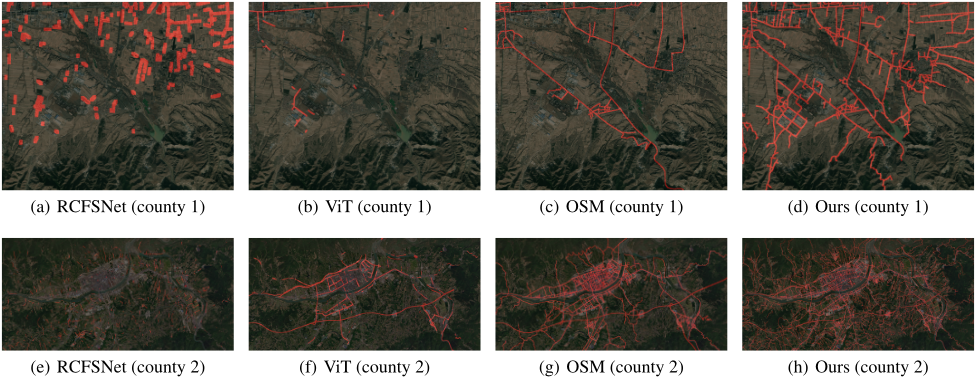
Then, we qualitatively evaluate the effectiveness of our generated dataset. Specifically, we select two areas from two impoverished counties (Lingqiu County and Xixiang County) with different populations. We overlap the extracted road network on the corresponding satellite imagery shown in Figure 3. In county 1, RCFSNet misclassifies the mountainous areas as roads. Vit can identify the roads, but the connectivity of roads is row. OSM shows the main roads in the mountainous areas, but it omits the other roads that lead to the industrial area or connect the households in a village. Our generated dataset covers most roads, including the primary and pavement roads. In county 2, RCFSNet shows discrete roads. ViT and OSM capture most main roads, such as the roads in the county center. However, our generated dataset shows the roads that go into mountainous areas and connect the neighborhoods. In conclusion, our proposed dataset covers more roads than baselines and guarantees the connectivity of roads.
4.3 Case Study
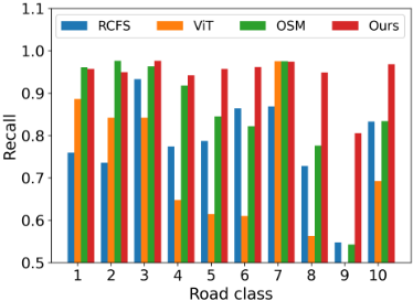
Next, we investigate the ability of our proposed framework to reconstruct different types of roads. Based on the width and speed limit of the roads, the ground truth road network is categorized into ten classes, i.e., class 1 being the highestand class 10 being the lowest-level road, starting with highway and ending with pathway. More specific road classifications are detailed in A.3. In impoverished counties, higherclass roads are less common. In contrast, lower-class roads are more necessary and valuable and often lack annotation in publicly available datasets. Therefore, the identification of lower-class roads holds greater significance. The average recognition ability, i.e., the recall metrics for different classes of roads in 2021, is shown in Figure 4, and the results of 2017 are in A.3. From the figure, we can see that when recognizing the high-class roads, OSM has the best performance, and our framework shows a comparable result. However, for the low-class roads (e.g., Ordinary Road and Village Internal Road), which are dominant roads in impoverished counties, our method shows the highest recall, demonstrating the ability of our proposed framework to help study the low-class roads for vulnerable communities.
4.4 Generated Road Network Dataset
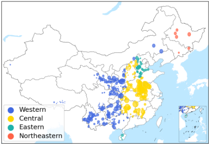
We generate the road network dataset covering over 794,178 km2 area in 382 impoverished counties located in 22 provinces in China in 2017 and 2021 using the proposed framework. The impoverished counties are selected from the file "List of 832 National Poverty-Stricken Counties" [The National Rural Revitalization Administration, 2014] in China. Our proposed road network dataset covers an overall road length of 1.034 million km and 17.048 million people in impoverished counties. The counties are assigned to China's four major economic regions, as shown in Figure 5. Most of the impoverished counties are from western and central economic regions, accounting for 90.6% of the selected counties. Besides, we provide the number of images, area, population, Gross Domestic Product (GDP), the added value of the secondary sector of the economy (SSE), and resident saving balance (Balance), road length, road density, and road length per capita in our dataset. Those socioeconomic indicators are collected from the "China County and City Statistical Yearbook" 2 . The detailed information on the road network dataset and economic indicators of impoverished counties in different economic regions are in B.1.
5 Socioeconomic Analysis
In this step, we analyze the scaling law of road networks with respect to population, the correlation between the road network and socioeconomic indicators, and the estimated impact of road networks on the economy. We select GDP, SSE, and balance as the indicators reflecting the regional economic development. Analysis about the variation in road length with respect to population and economic regions are shown in B.2 and B.3, respectively.
2 http://www.stats.gov.cn/zs/tjwh/tjkw/tjzl/202302/ t20230215 1908004.html
5.1 Scaling Law of Road Network
The scaling law describes the relationship between socioeconomic factors and infrastructure development as cities grow [Bettencourt, 2013]. It helps in studying and predicting infrastructure correlation with population growth. In this section, we study the scaling law between the extracted road network representing the infrastructure status and population in impoverished counties. The scaling law is defined as
where Y is the road infrastructure, i.e., road length in our dataset, X is the population, and c and z are the estimated parameters.
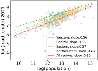
The fitting curves between the log(population) and log(road length) in 2021 is shown in Figure 6. Overall, the slope for all counties is 0.6, showing a sublinear form. The slope is similar to the findings of network length in theoretical computation [Bettencourt, 2013]. Then, from the perspectives of different regions, the slopes of the western and central regions in 2021 show a big gap, demonstrating the uneven development of the road network spatially. The slope for the northeastern region is relatively low, showing that the road network might get saturated. The analysis of year 2017 is shown in B.4.
5.2 Correlation Analysis of Road Network
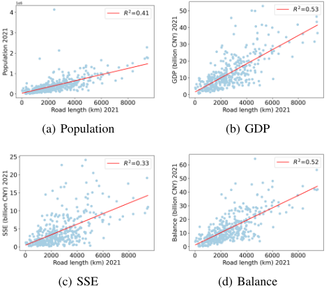
The road network is considered the backbone of an area and is related to regional socioeconomic status. In this part, we analyze the correlation between the road network length and regional socioeconomic indicators, i.e., population, GDP, SSE, and balance. The correlation between road length and socioeconomic indicators in 2021 is shown in Figure 7. The correlation results in 2017 are shown in B.5. We can see that the road length and GDP show the highest R2 [Lewis-Beck and Lewis-Beck, 2015], confirming that road network length can be used as an indicator for GDP. Second, the resident saving balance shows a similar R2 . However, the population and SSE show low R2 . These findings are of importance for subsequent research on vulnerable populations. By observing changes in the road network, a rough estimate of socioeconomic indicators can be obtained, facilitating the formulation and implementation of subsequent policies.
5.3 Estimated Impacts of Road Network
In this step, we study the economic impact of only road networks in impoverished counties with our produced road network dataset, i.e., neglecting other factors such as investment, whether the road network growth from the year 2017 to 2021 has a positive impact on regional GDP, SSE, and Balance. Specifically, we apply the Difference-in-difference (DiD) [Abadie, 2005] method to study the causal effects of road networks.
We implement the DiD as a fixed effects regression [Ratledge et al., 2022]:
where i is the subscript for county i, and t is time, Yi,t is the socioeconomic indicator of county i in year t, β is the treatment effects, (Di×Ti) is the product of dummy variables Di (treatment or control group) and Ti (pre- or post-treatment period), γi is the unit fixed effect, δt is the time fixed effect, and ϵit captures the errors.
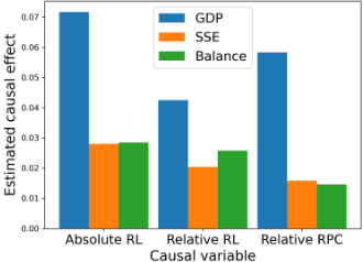
We divide the counties into control and treatment groups according to the metrics: absolute road length (absolute RL) variation, relative road length (relative RL) variation, and relative road length per capita (relative RPC) variation from year 2017 to 2021. The calculations are provided in B.6. For each metric, the counties that belong to the bottom 50% of counties are selected as the control group, and the counties belonging to the top 40% of counties are viewed as the treatment group. In our dataset, 2021 is the post-treatment and 2017 is the pretreatment period.
The estimated causal effects of road networks on GDP, SSE, and balance are shown in Figure 8. GDP is most affected by road network, and the absolute improvement of road network length shows the highest effect. The relative road network length growth and relative per capita road length also show positive effects. However, many other factors, such as investment, consumption, and inflation [Anbao and Danhua, 2011; Alagic, 2017], may influence economic growth and will be analyzed in future work.
6 Conclusion
This paper proposes a scalable framework for extracting road networks in impoverished counties from satellite imagery. Extensive experiments on real-world road data validate the effectiveness of the framework. Besides, we generate a comprehensive road network dataset covering 382 impoverished counties. Performing socioeconomic analysis on our generated road network dataset shows constructing road infrastructure positively correlates with economic development.
Our proposed framework can help with monitoring SDG processes such as poverty eradication or infrastructure accessibility in many impoverished counties where the publicly available road data is not complete. Our work also contributes to the goal of LNOB. By assessing the roads connecting various regions, we provide improved access and opportunities for impoverished areas, thus helping ensure access to education, healthcare, and other essential services.
Acknowledgements
This paper is supported in part by the National Natural Science Foundation of China under Grant U22B2057, Grant 62171260, and Grant U21B2036.
@inproceedings{ijcai2024p831,
  title     = {From Pixels to Progress: Generating Road Network from Satellite Imagery for Socioeconomic Insights in Impoverished Areas},
  author    = {Xi, Yanxin and Liu, Yu and Liu, Zhicheng and Tarkoma, Sasu and Hui, Pan and Li, Yong},
  booktitle = {Proceedings of the Thirty-Third International Joint Conference on
               Artificial Intelligence, {IJCAI-24}},
  publisher = {International Joint Conferences on Artificial Intelligence Organization},
  editor    = {Kate Larson},
  pages     = {7509--7517},
  year      = {2024},
  month     = {8},
  note      = {AI for Good},
  doi       = {10.24963/ijcai.2024/831},
  url       = {https://doi.org/10.24963/ijcai.2024/831},
}
TY - CPAPER TI - From Pixels to Progress: Generating Road Network from Satellite Imagery for Socioeconomic Insights in Impoverished Areas AU - Xi, Yanxin AU - Liu, Yu AU - Liu, Zhicheng AU - Tarkoma, Sasu AU - Hui, Pan AU - Li, Yong T2 - Proceedings of the Thirty-Third International Joint Conference on Artificial Intelligence, IJCAI-24 PB - International Joint Conferences on Artificial Intelligence Organization PY - 2024 SP - 7509 EP - 7517 DO - 10.24963/ijcai.2024/831 UR - https://doi.org/10.24963/ijcai.2024/831 ER -Copied
Machine-readable versions of this paper, for tools and AI agents: