AI and Decision Support for Sustainable Socio-Ecosystems
Proceedings of the Thirty-Second International Joint Conference on Artificial Intelligence. AI for Good - Projects. Pages 6370-6377.
https://doi.org/10.24963/ijcai.2023/707
Keywords
- AI for Good - Projects: Constraint Satisfaction and Optimization
- AI for Good - Projects: Planning and Scheduling
- AI for Good - Projects: Machine Learning
- AI for Good - Projects: Multidisciplinary Topics and Applications
Abstract
The conservation and the restoration of biodiversity, in accordance with human well-being, is a necessary condition for the realization of several Sustainable Development Goals. However, there is still an important gap between biodiversity research and the management of natural areas. This research project aims to reduce this gap by proposing spatial planning methods that robustly and accurately integrate socio-ecological issues. Artificial intelligence, and notably Constraint Programming, will play a central role and will make it possible to remove the methodological obstacles that prevent us from properly addressing the complexity and heterogeneity of sustainability issues in the management of ecosystems. The whole will be articulated in three axes: (i) integrate socio-ecological dynamics into spatial planning, (ii) rely on adequate landscape metrics in spatial planning, (iii) scaling up spatial planning methods performances. The main study context of this project is the sustainable management of tropical forests, with a particular focus on New Caledonia and West Africa.
- [Albert et al., 2017] Cécile H. Albert, Bronwyn Rayfield, Maria Dumitru, and Andrew Gonzalez. Applying network theory to prioritize multispecies habitat networks that are robust to climate and land-use change. Conservation Biol- ogy, 31(6):1383-1396, December 2017.
- [Allegretti et al., 2018] Stefano Allegretti, Federico Bolelli, Michele Cancilla, and Costantino Grana. Optimiz- ing GPU-Based Connected Components Labeling Algo- rithms. In 2018 IEEE International Conference on Image Processing, Applications and Systems (IPAS), pages 175- 180, December 2018.
- [Arlettaz et al., 2010] Raphaël Arlettaz, Michael Schaub, Jérôme Fournier, Thomas S. Reichlin, Antoine Sierro, James E. M. Watson, and Veronika Braunisch. From Pub- lications to Public Actions: When Conservation Biologists Bridge the Gap between Research and Implementation. BioScience, 60(10):835-842, November 2010.
- [Ball et al., 2009] Ian R Ball, Hugh P Possingham, and Matthew E Watts. Marxan and Relatives: Software for Spatial Conservation Prioritization. Oxford University Press, 2009.
- [Balmford and Cowling, 2006] Andrew Balmford and Richard M. Cowling. Fusion or Failure? The Fu- ture of Conservation Biology. Conservation Biology, 20(3):692-695, June 2006.
- [Bessière et al., 2015] Christian Bessière, Emmanuel Hébrard, George KATSIRELOS, and Toby Walsh. Reasoning about Connectivity Constraints. In IJCAI: International Joint Conference on Artificial Intelligence, pages 2568-2574, Buenos Aires, Argentina, July 2015. AAAI Press. IJCAI
- [Church et al., 1996] Richard L. Church, David M. Stoms, and Frank W. Davis. Reserve selection as a maxi- mal covering location problem. Biological Conservation, 76(2):105-112, January 1996.
- [Cocks and Baird, 1989] K. D. Cocks and I. A. Baird. Using mathematical programming to address the multiple reserve selection problem: An example from the Eyre Peninsula, South Australia. Biological Conservation, 49(2):113-130, January 1989.
- [Díaz et al., 2020] S. Díaz, J. Settele, E. Brondízio, H. Ngo, M. Guèze, J. Agard, A. Arneth, P. Balvanera, K. Brauman, S. Butchart, K. Chan, L. Garibaldi, K. Ichii, J. Liu, S. Sub- rmanian, G. Midgley, P. Miloslavich, ... and C. Zayas. The global assessment report on biodiversity and ecosystem services: Summary for policy makers. Intergovernmental Science-Policy Platform on Biodiversity and Ecosystem , 2019.
- [Estopinan et al., 2022] Joaquim Estopinan, Maximilien Servajean, Pierre Bonnet, Franc ¸ois Munoz, and Alexis Joly. Deep Species Distribution Modeling From Sentinel- 2 Image Time-Series: A Global Scale Analysis on the Orchid Family. Frontiers in Plant Science, 13:839327, April 2022.
- [Fages et al., 2013] Jean-Guillaume Fages, Gilles Chabert, and Charles Prud'Homme. Combining finite and continu- ous solvers Towards a simpler solver maintenance. In The 19th International Conference on Principles and Practice of Constraint Programming, TRICS'13 Workshop: Tech- niques foR Implementing Constraint programming Sys- tems, Uppsala, Sweden, September 2013.
- [Francis and Porter, 2011] C. A. Francis and P. Porter. Ecol- ogy in Sustainable Agriculture Practices and Systems. Critical Reviews in Plant Sciences, 30(1-2):64-73, Jan- uary 2011.
- [Frazier and Kedron, 2017] Amy E. Frazier and Peter Ke- dron. Landscape Metrics: Past Progress and Future Direc- tions. Current Landscape Ecology Reports, 2(3):63-72, September 2017.
- [Freuder, 2018] Eugene C. Freuder. Progress towards the Holy Grail. Constraints, 23(2):158-171, April 2018.
- [Gent et al., 2018] Ian P. Gent, Ian Miguel, Peter Nightin- gale, Ciaran Mccreesh, Patrick Prosser, Neil C. A. Moore, and Chris Unsworth. A review of literature on parallel constraint solving. Theory and Practice of Logic Program- ming, 18(5-6):725-758, September 2018.
- [Griscom et al., 2017] Bronson W. Griscom, Justin Adams, Peter W. Ellis, Richard A. Houghton, Guy Lomax, Daniela A. Miteva, William H. Schlesinger, David Shoch, Juha V. Siikamäki, Pete Smith, Peter Woodbury, Chris Zganjar, Allen Blackman, João Campari, Richard T. Co- nant, Christopher Delgado, Patricia Elias, ... and Joseph Fargione. Natural climate solutions. Proceedings of the National Academy of Sciences, 114(44):11645-11650, October 2017.
- [Haider et al., 2018] Zulqarnain Haider, Hadi Charkhgard, and Changhyun Kwon. A robust optimization approach for solving problems in conservation planning. Ecological Modelling, 368:288-297, January 2018.
- [Hanson et al., 2020] Jeffrey O. Hanson, Richard Schus- ter, Nina Morrell, Matthew Strimas-Mackey, Matthew E. Watts, Peter Arcese, Joseph Bennett, and Hugh P. Possing- ham. Prioritizr: Systematic Conservation Prioritization in R, May 2020.
- [Hesselbarth et al., 2019] Maximilian H. K. Hesselbarth, Marco Sciaini, Kimberly A. With, Kerstin Wiegand, and Jakub Nowosad. Landscapemetrics: An open- source R tool to calculate landscape metrics. Ecography, 42(10):1648-1657, 2019.
- [Justeau-Allaire et al., 2019] Dimitri Justeau-Allaire, Philippe Vismara, Philippe Birnbaum, and Xavier Lorca. Systematic Conservation Planning for Sustainable Land- use Policies: A Constrained Partitioning Approach to Reserve Selection and Design. In Proceedings of the Twenty-Eighth International Joint Conference on Artifi- cial Intelligence, pages 5902-5908, Macao, China, 2019. International Joint Conferences on Artificial Intelligence Organization.
- [Justeau-Allaire et al., 2021] Dimitri Justeau-Allaire, Ghis- lain Vieilledent, Nicolas Rinck, Philippe Vismara, Xavier Lorca, and Philippe Birnbaum. Constrained optimization of landscape indices in conservation planning to support ecological restoration in New Caledonia. Journal of Ap- plied Ecology, 58(4):744-754, 2021.
- [Justeau-Allaire et al., 2023] Dimitri Justeau-Allaire, Jef- frey O. Hanson, Guillaume Lannuzel, Philippe Vismara, Xavier Lorca, and Philippe Birnbaum. Restoptr: An R package for ecological restoration planning. Restoration Ecology, e13910, 2023.
- [Justeau-Allaire, 2020] Dimitri Justeau-Allaire. Constraint- Based Systematic Conservation Planning, a Generic and Expressive Approach. Application to Decision Support in the Conservation of New Caledonian Forests. PhD thesis, Université de Montpellier, December 2020.
- [Katila et al., 2019] Pia Katila, Carol J. Pierce Colfer, Wil de Jong, Glenn Galloway, Pablo Pacheco, and Georg Winkel. Sustainable Development Goals. Cambridge Uni- versity Press, December 2019.
- [Keenan et al., 2015] Rodney J. Keenan, Gregory A. Reams, Frédéric Achard, Joberto V. de Freitas, Alan Grainger, and Erik Lindquist. Dynamics of global forest area: Results from the FAO Global Forest Resources Assessment 2015. Forest Ecology and Management, 352:9-20, September 2015.
- [Kirkpatrick, 1983] J. B. Kirkpatrick. An iterative method for establishing priorities for the selection of nature re- serves: An example from Tasmania. Biological Conser- vation, 25(2):127-134, February 1983.
- [Lombardi and Milano, 2018] Michele Lombardi and Michela Milano. Boosting Combinatorial Problem Modeling with Machine Learning. In Proceedings of the Twenty-Seventh International Joint Conference on Artificial Intelligence, pages 5472-5478, Stockholm, Sweden, July 2018. International Joint Conferences on Artificial Intelligence Organization. [Lombardi et al., 2017] IJCAI
- Michele Lombardi, Michela Milano, and Andrea Bartolini. Empirical decision model learning. Artificial Intelligence, 244:343-367, March 2017.
- [Margules and Pressey, 2000] Chris R. Margules and Robert L. Pressey. Systematic conservation planning. Nature, 405(6783):243-253, May 2000.
- [Mittermeier et al., 2005] Russell A. Mittermeier, Patri- cio Robles Gil, Michael Hoffman, John Pilgrim, Thomas Brooks, Cristina Goettsch Mittermeier, John Lamoreux, and Gustavo A. B. da Fonseca. Hotspots Revisited: Earth's Biologically Richest and Most Endangered Terres- trial Ecoregions. Conservation International, July 2005.
- [Moilanen et al., 2009] Atte Moilanen, Heini Kujala, and John R Leathwick. The Zonation framework and software for conservation prioritization. Spatial conservation pri- oritization, 135:196-210, 2009.
- [Potapov et al., 2017] Peter Potapov, Matthew C. Hansen, Lars Laestadius, Svetlana Turubanova, Alexey Yaroshenko, Christoph Thies, Wynet Smith, Ilona Zhuravleva, Anna Komarova, Susan Minnemeyer, and Elena Esipova. The last frontiers of wilderness: Tracking loss of intact forest landscapes from 2000 to 2013. Science Advances, 3(1):e1600821, 2017.
- [Rossi et al., 2006] Edited F Rossi, P van Beek, and T Walsh. Handbook of Constraint Programming. Elsevier, 2006.
- [Saura and Pascual-Hortal, 2007] Santiago Saura and Lucía Pascual-Hortal. A new habitat availability index to in- tegrate connectivity in landscape conservation planning: Comparison with existing indices and application to a case study. Landscape and Urban Planning, 83(2):91-103, November 2007.
- [Schreckenberg et al., 2018] Kate Schreckenberg, Mahesh Poudyal, and Georgina Mace, editors. Ecosystem Services and Poverty Alleviation: Trade-offs and Governance. Tay- lor & Francis, 2018.
- [Silvestro et al., 2022] Daniele Silvestro, Stefano Goria, Thomas Sterner, and Alexandre Antonelli. Improving bio- diversity protection through artificial intelligence. Nature Sustainability, 5(5):415-424, May 2022.
- [Stallard et al., 2007] RF Stallard, H Elsenbeer, FL Ogden, and JS Hall. The agua salud project, central panama. In AGU Fall Meeting Abstracts, volume 2007, pages H21I- 01, 2007.
- [Vancutsem et al., 2021] C. Vancutsem, F. Achard, J.-F. Pekel, G. Vieilledent, S. Carboni, D. Simonetti, J. Gallego, L. E. O. C. Aragão, and R. Nasi. Long-term (1990-2019) monitoring of forest cover changes in the humid tropics. Science Advances, 7(10):eabe1603, March 2021.
- [Welzl, 1991] Emo Welzl. Smallest enclosing disks (balls and ellipsoids). In Hermann Maurer, editor, New Results and New Trends in Computer Science, volume 555, pages 359-370. Springer-Verlag, Berlin/Heidelberg, 1991.
- [Williams et al., 2020] David R. Williams, Andrew Balm- ford, and David S. Wilcove. The past and future role of conservation science in saving biodiversity. Conservation Letters, n/a(n/a):e12720, 2020.
- [Zhang et al., 2015] Jianting Zhang, Simin You, and Le Gru- enwald. Large-scale spatial data processing on GPUs and GPU-accelerated clusters. SIGSPATIAL Special, 6(3):27- 34, April 2015.
- [Zinsstag et al., 2011] J. Zinsstag, E. Schelling, D. Waltner- Toews, and M. Tanner. From "one medicine" to "one health" and systemic approaches to health and well-being. Preventive Veterinary Medicine, 101(3):148-156, Septem- ber 2011.
- [Zurell et al., 2010] Damaris Zurell, Uta Berger, Juliano S. Cabral, Florian Jeltsch, Christine N. Meynard, Tamara Münkemüller, Nana Nehrbass, Jörn Pagel, Björn Reinek- ing, Boris Schröder, and Volker Grimm. The virtual ecol- ogist approach: Simulating data and observers. Oikos, 119(4):622-635, 2010.
References were extracted automatically from the PDF and may contain errors.
Full text extracted automatically from the PDF; figures, tables and equations may differ. The PDF is the version of record.
1 Problematic: The Global Biodiversity Crisis and Our Failure To Address It
We are facing a biodiversity crisis unprecedented in our history. The current rate of species extinction is a thousand times higher than the background extinction rate, and more than one million species are threatened with extinction [D´ıaz et al., 2020]. Human activities are the principal driver of this crisis, land use change (e.g. agricultural expansion, urbanization, mineral resources exploitation) being the most impacting of these activities. Besides, the Aichi targets for 2020 to halt biodiversity loss have not been met. One of the reasons that have been identified to explain this failure is the persisting gap between research and operational management, the so-called "research-implementation gap" [Williams et al., 2020]. Indeed, when it comes to biodiversity, only a few studies take into account socio-economic factors as part of the problem [Arlettaz et al., 2010]. Even fewer studies involve stakeholders (e.g. land managers, associations, local populations) and social sciences [Balmford and Cowling, 2006].
However, these failures to conserve and restore biodiversity globally taught us several things. The most important lesson is that biodiversity research must be involved and transdisciplinary, and based on sound socio-ecological knowledge. In the last decades, computer sciences have played an essential role in advancing biodiversity research, which in return became a source of inspiration for these theoretical disciplines. Most advances have occurred in data management and analysis, from global biodiversity databases (GBIF) to advanced analytical models (e.g. species distribution models). Like in many other disciplines, AI has been a game changer in many of these advances. However, one aspect of AI remains less explored than the others in biodiversity research: symbolic AI and its capabilities for decision support.
To the best of my knowledge, one of the first usages of symbolic AI in biodiversity research was the identification of representative protected area networks through spatial planning [Kirkpatrick, 1983]. In this regard, an interesting anecdote is that Kirkpatrick was a forest ecologist who probably did not know that his approach could fit within the scope of symbolic AI. A few years after this work, computer scientists highlighted this fact [Cocks and Baird, 1989]. More than thirty years after, and after a few heated debates between computed scientists and ecologists, spatial planning is an established topic within biodiversity research [Margules and Pressey, 2000], yet still a niche domain with few concrete applications. I, therefore, argue that greater involvement of AI research in a transdisciplinary way with ecologists, social scientists, and non-academic stakeholders could usher in a new era for spatial planning.
2 SDGs and LNOB Principles: Why Spatial Planning Is So Important?
From the most rural populations to those in large megacities, we, humans, are all dependent on biodiversity in many aspects. Although only two of the UN Sustainable Development Goals (SDGs) are directly focused on biodiversity (SDG 14: Life below water, SDG 15: Life on land), almost all SDGs are indirectly related to ecosystem health. For example, healthy ecosystems provide services that can help alleviate poverty (SDG 1) [Schreckenberg et al., 2018]. Oceans and forests provide food resources and are a source of inspiration to design sustainable food systems (SDG 2) [Francis and Porter, 2011]. Finally, forests are known to protect watersheds and provide clean water (SDG 6) [Katila et al., 2019], and their exploitation and degradation are related to the emergence of zoonotic epidemics (e.g. Ebola, COVID19) [Zinsstag et al., 2011] (SDG 3).
As explained in Section 1, land use change is the most detrimental human activity to biodiversity and ecosystem health. It is therefore clear that more sustainable land use management strategies are one of the most important prerequisites if we want to reach the UN SDGs. This is why spatial planning, used to identify sustainable socio-ecosystem trajectories, is so important. Not only it could help to reach the SDGs but also contribute to the rebalancing of inequalities between countries. Indeed, a large proportion of habitat degradation and biodiversity loss nowadays occur in tropical regions, mainly covered by developing countries. In this respect, the case of forest ecosystems is striking. Indeed, tropical forests are the richest, the most productive, and a vital resource for many societies. Yet, between 1990 and 2015, about 129 million hectares were lost, and most of this loss occurred in tropical forests [Keenan et al., 2015].
3 Overview of Current Spatial Planning Approaches and Their Limitations
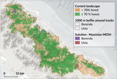
In its most general and abstract form, spatial planning can be defined as a constrained space partitioning problem, with or without optimization objective(s). From biodiversity conservation and restoration (see Figure 1) to ecological agriculture and sustainable cities design, spatial planning applications are various, highly diverse, and involve complex spatial and heterogeneous datasets such as ecological data (e.g. species occurrences, habitat quality, dispersal capabilities) or socioeconomic data (e.g. land/sea acquisition and opportunity costs, traditional land-use, land/sea legislation). They also involve solving complex and interrelated combinatorial problems, such as set covering and multiconnected graph partitioning problems [Church et al., 1996; Bessi`ere et al., 2015].
Current spatial planning approaches mainly focus on identifying candidate areas for biodiversity conservation or restoration, taking into account the spatial distribution of biodiversity features and basic socioeconomic criteria such as land acquisition cost and land accessibility. [Margules and Pressey, 2000; Justeau-Allaire, 2020]. The methods used to solve these problems are various and include greedy algorithms [Moilanen et al., 2009], metaheuristics [Ball et al., 2009], mixed-integer linear programming (MILP) [Hanson et al., 2020], constraint programming (CP) [Justeau-Allaire et al., 2019], and reinforcement learning [Silvestro et al., 2022].
Given the wide variety and heterogeneity of real-world problems, flexibility and expressiveness are two essential aspects of spatial planning tools, along with their availability as free and open software packages. In this regard, declarative approaches such as MILP or CP are well-adapted paradigms to design such tools, but there remain several technical challenges to tackle in order to fully address sustainability stakes in spatial planning. Among the various limitations of existing spatial planning models, I identified three main methodological obstacles which, if removed, would make it possible to propose spatial planning approaches better adapted to the complexity and diversity of real-world socio-ecological issues. These obstacles are:
- The lack of a robust integration of socio-ecological dynamics.
- The lack of accuracy with which socio-ecological challenges are taken into account.
- The currently inadequate balance between modelling accuracy and computational efficiency.
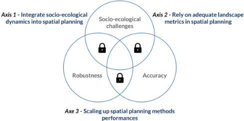
These obstacles highlight three important attributes of spatial planning: socio-ecological challenges, robustness, and accuracy. Indeed, the main objective of spatial planning is to provide decision support in addressing socio-ecological challenges. The proposed solutions must be robust over space and time. Moreover, real-world issues must be accurately represented, and this accuracy must be robust to different space and time scales. In figure 2, I summarized these three obstacles and attributes and suggested three research axes that could help build a new generation of spatial planning approaches. The next section develops and details these axes.
4 Towards a NewGeneration of CP-Based and AI-Powered Spatial Planning Approaches
While it is clear that AI can greatly contribute to empowering spatial planning, underlying sustainability issues also are ideal terrain for cross-fertilization and new AI technical developments. In this respect, this project's strategy is to build upon Constraint Programming (CP) as an integrative paradigm to develop advanced spatial planning approaches that rely on techniques from different areas of AI. CP is a declarative paradigm for modelling and solving constraint satisfaction and constrained optimization problems. Flexibility, expressiveness, and extensibility are among the greatest strengths of this approach. Indeed, the CP paradigm is built around an abstract modelling language which allows representing decision and optimization problems with a wide variety of variables types (e.g. integers, sets, graphs, tasks) and a wide variety of constraints types (e.g. logical, arithmetic) [Rossi et al., 2006; Freuder, 2018]. Because CP solvers encapsulate independent logic in variables and constraints, the possibilities for extension and hybridization with other approaches are virtually infinite [Fages et al., 2013; Lombardi and Milano, 2018]. Consequently, the CP paradigm is an excellent candidate to integrate the high variety of spatial planning issues into a flexible and expressive framework. In the following, I detail each research axis depicted in Figure 2, its associated methodological challenges, and my strategy to overcome them through promising extensions of the CP paradigm.
4.1 Axis 1: Integrate Socio-Ecological Dynamics Into Spatial Planning
Spatial planning is a prescriptive analysis tool that relies on constrained optimization procedures and ecological, environmental, social and economic data. To provide reliable and robust management plans, it is essential to take into account socio-ecological dynamics (i.e. the way human societies and their environment interact over space and time) in their design. These dynamics are currently not, or hardly, taken into account, and the proposed approaches are casespecific and applied at a small scale [Albert et al., 2017; Haider et al., 2018]. Predictive models are useful to describe and forecast socio-ecological dynamics (e.g. population dynamics, climate change, deforestation, predictive agriculture). However, their integration in spatial planning is currently only possible (i) upstream of the optimization procedure, in the form of a static input layer, or (ii) downstream of the optimization procedure, to evaluate the impact of a scenario. In the first case, the prediction does not take into account the actions that one seeks to plan. In the second case, the prescription cannot take advantage of the predictions to identify the best trade-offs. A recent approach based on reinforcement learning [Silvestro et al., 2022] addresses this issue but at the price of many missing additional constraints that are essential in most spatial planning projects (e.g. connectivity). To properly address socio-ecological interactions and their dynamics, it is, therefore, necessary to go beyond the current approaches, by integrating predictive models into constrained optimization procedures. In practice, this implies being able to anticipate the impact of a partial spatial management plan on socio-ecological dynamics and rely on this impact to guide its further construction. This result can only be achieved through a closer coupling between the methods that construct spatial management plans (constrained optimization) and the ones that analyse their impact on socioecological dynamics (predictive models).
To achieve the objectives of this research axis, I plan to develop methods that combine techniques from machine learning (ML) and automated reasoning (AR). On the one hand, ML approaches are based on data and can perform complex tasks in short amounts of time, which makes them well-adapted to implement predictive models. On the other hand, AR approaches are based on models and can solve complex problems in a generic way and with a high level of interpretability. To benefit from the advantages of both paradigms in the context of spatial planning, the Empirical Model Learning (EML) approach, which allows the integration of ML models in constrained optimization procedures [Lombardi et al., 2017] is a promising research direction. The main idea behind EML is to embed ML models into constraint filtering algorithms in order to estimate bounds and detect contradictions during the combinatorial search procedure. While several existing ML models could already be useful for spatial planning, such as species distribution or deforestation models [Vancutsem et al., 2021; Estopinan et al., 2022], the main challenge is to ensure their ability to output reliable bounds from a spatial plan's partial instantiation.
4.2 Axis 2: Rely on Adequate Landscape Metrics in Spatial Planning
The increasing availability of high-resolution spatiotemporal landscape data opens up many perspectives for spatial planning. In this regard, several landscape metrics can help to understand and measure socio-ecological processes from landscape patterns [Hesselbarth et al., 2019]. In addition, several advanced simulation models are available to systematically explore the relationships between landscape patterns and socio-ecological processes [Zurell et al., 2010]. Despite the existence of these advanced tools for assessment, spatial planning approaches rely on very simple landscape metrics with little ecological relevance. This methodological gap leads to a mismatch between the amount of available data and our ability to use it for decision support. Recent approaches based on CP have shown promising results in this regard thanks to the integration of complex and non-linear habitat fragmentation and connectivity indices in ecological restoration planning [Justeau-Allaire et al., 2021; Justeau-Allaire et al., 2023]. However, a lot remains to achieve in this direction. Indeed, numerous landscape indices are available to evaluate socio-ecological processes [Frazier and Kedron, 2017]. This variety is necessary, as it allows us to understand the high diversity of contexts that can arise in different case studies. Therefore, it appears necessary to fill the current methodological gap between assessment and prescription tools through the integration of as many landscape indices as possible in spatial planning to address this diversity in decision support.
This axis will mainly involve designing and implementing constraint filtering algorithms for advanced landscape indices. Such indices can be computationally expensive in a constraint propagation context, as they involve tasks such as computing all-pairs-shortest paths in large spatial graphs [Saura and Pascual-Hortal, 2007]. They also involve a spatial dimension for which CP solvers are currently not very well adapted. Consequently, the main challenge of this research axis will be the design of suited data structures and algorithms to handle efficiently the spatial dimension of landscape indices. The EML approach described in Axis 1 has great potential to advance in this direction, especially for efficient spatial pattern identification, where ML approaches are particularly relevant. Another promising perspective is the adaptation of algorithms from algorithmic geometry and computer vision for filtering. To my knowledge, none or very few studies have explored the potential of this research direction. However, we already had encouraging results with the implementation of a linear time propagator for the smallest enclosing circle problem relying on Welzl's algorithm [Welzl, 1991], and its application in a reforestation planning project [Justeau-Allaire et al., 2021]. In this use case, the aimwas to identify optimal areas for reforestation subject to operational constraints, such as spatial compactness. The filtering based on algorithmic geometry was much more efficient than the naive approach based on pairwise distance constraints, and the adaptation of Welzl's algorithm for filtering was straightforward and particularly suitable for propagation due to its incremental nature.
4.3 Axis 3: Scaling Up Spatial PlanningMethods Performances
Symbolic AI approaches, such as MILP or CP, offer guarantees and a level of flexibility that can be critical in spatial planning projects. Moreover, their expressiveness (i.e. the breadth and variety of problems that can be represented and solved) is a great asset to reflect the diversity of issues into generic modelling frameworks. However, the spatial resolution of the problems that can be solved with such approaches is still limited. On the other hand, heuristic approaches are computationally efficient, but they offer much less flexibility and expressiveness than symbolic approaches. While expressiveness is essential for reliable decision support, spatial resolution is also necessary to provide accurate and large-scale solutions. To better address real spatial planning issues, it is thus necessary to readjust the balance between model accuracy and computational efficiency.
In this respect, I expect that the methodological developments planned in Axis 1 and Axis 2 will help to move in this direction. First, the implementation of EML techniques in CP-based spatial planning will help improve the performances of the optimization procedure by delegating tasks that are currently expensive to compute symbolically to ML models. On the other hand, the strengthening of spatial reasoning with techniques from algorithmic geometry and computer vision will also be beneficial for spatial planning performances. Finally, I plan to investigate the application of high-performance computing (HPC), and in particular parallelization (on CPU and GPU) in CP-based spatial planning. Although there is currently no general efficient solution for parallel constraint solving [Gent et al., 2018], its restriction to spatial planning could greatly benefit from HPC. Indeed, spatial planning is based on raster and graph data structures, which are both suitable for parallel computing on CPU and GPU, with considerable gains over sequential algorithms [Zhang et al., 2015; Allegretti et al., 2018]. Even if the most obvious perspective is the parallelization of filtering algorithms, it is also likely that the careful design of data structures tailored for high-performance spatial planning will lead to many advances.
5 Study Context: Tropical Forests and Their People
Deforestation is a particularly alarming consequence of landuse change, as forests are home to about 50% of the world's species, contain about 50% of the world's carbon stocks, and provide ecosystem services essential to our well-being. Globally, forest area declined by 129 million hectares between 1990 and 2015, mainly in tropical forests, which are the richest, the most productive, and on which many societies from developing countries depend [Keenan et al., 2015]. Consequently, this biome will be my main study context, and my main motivation to use and improve spatial planning as a decision-support tool to identify sustainable management trajectories for tropical forests.
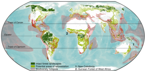
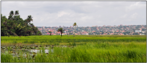
In particular, I will focus on the biodiversity hotspot "Guinean Forest of West Africa" (see Figure 3 and 4), with a focus on sustainability issues in the Ziama Biosphere Reserve in Guinea (Conakry). In this area, local populations depend on the ecosystem services provided by the forest. Furthermore, development and capacity-building issues are important in Guinea, one of the least developed countries in the world (178th out of 189 according to the UN). At the same time, I will remain involved in the biodiversity hotspot of New Caledonia (see Figure 3 and 5), a study area in which, with the AMAP Lab, we have been developing and applying spatial planning approaches with local stakeholders over the past decade. This well-established network of collaborations in New Caledonia includes local scientists, NGOs (e.g. WWF, Conservation International), private companies (e.g. mining companies, environmental consultancies), and local authorities. A large amount of data is also already available, making New Caledonia an ideal laboratory for shortterm testing. Incidentally, I will also explore potential collaborations with researchers from the Smithsonian Tropical Research Institute in Panama, who have implemented largescale experimental reforestation plots (Agua Salud project [Stallard et al., 2007]), providing many opportunities to test and evaluate spatial planning methods.

6 Expected Results, Challenges, Evaluation Criteria, and Limitations
In this project, I expect results at different time scales. In the short term, I plan to improve the CP-based spatial planning approaches that we have been developing over the past decade with the AMAP Lab [Justeau-Allaire et al., 2019; Justeau-Allaire, 2020; Justeau-Allaire et al., 2021] with the methods described in Section 4. In particular, I will rely on the restoptr restoration planning software, which we recently released [Justeau-Allaire et al., 2023], to make new methodological results widely available as quickly as possible. The research Axis 1 is, to my opinion, the most technically challenging, and thus will be developed with a long-term perspective. However, simple proofs of concepts could be tested as we move forward in the field, given the strong network of collaborations of the AMAP Lab with stakeholders in New Caledonia. The research Axis 2 is probably the simplest from a technical point of view, but its application is more tedious. Indeed, the reliability of a given landscape pattern for decision support needs to be assessed with field data collection campaigns, which takes time. Therefore, the strategy will consist in relying as much as possible on existing datasets to test and apply the methods developed. Finally, Axis 3 is not as exploratory as Axis 1, but I expect it to involve more technical work than Axis 2, especially in what refers to HPC. I expect to publish the first contributions from this Axis within a year or two. Overall, the main evaluation criteria will be:
- The number of successful applications of spatial planning approaches in real case studies.
- The level of satisfaction with the proposed results by local stakeholders, and the quality of the discussions they will open up between scientists, associations, environmental managers, and local populations.
- The number of collaborations with stakeholders from developing regions.
- The number of students trained, particularly students from developing regions.
- At the academic level, the number of publications, especially those published in sustainability journals and conferences, co-authored with partners from study areas.
I wish to emphasize that this project is a long-term one, if not a lifelong one. The main motivations are the successful applications of the developed methods and their contributions to decision-support in the field. This implies building strong and long-term partnerships based on mutual trust. Such a thing requires a lot of time and an investment that goes far beyond academic work. From the long-term experience of the AMAP Lab in New Caledonia, we know that human factors can be the most limiting. As researchers, the greatest challenges are a lot of patience, major communication and outreach efforts, and perseverance. Being out of the comfort zone as much as possible and setting up working contexts where different disciplines and cultural backgrounds interact daily are, to my opinion, two necessary conditions for reaching transdisciplinarity.
7 Ethical Considerations
I aim to conduct this project in the most ethical way possible, by making equity a core principle of partnerships. Although this project was initiated by ecology and AI, it aims for transdisciplinarity in an international and multi-cultural context. The role of each discipline, academic or not, will be fairly recognized in this project. Another important principle will be the respect of everyone involved, regardless of gender, nationality, beliefs or opinions. Finally, this project aims to defend common interests, through SGDs and the LNOB principles. Particular care will be taken to avoid corruption and conflicts of interest.
8 Implementation Plan
The first three years of this project will be devoted to strengthening spatial planning methods, according to the three research axes described in Section 4. During this period, I will take advantage of established collaborations in New Caledonia to apply, test, and improve technical development according to feedback from the field. I will also establish collaborations with researchers from the Smithsonian Tropical Research Institute in Panama, and experiment with the potential of the data collected in their experimental reforestation plot network to address new spatial planning issues. In parallel, I will devote part of my time to building new partnerships, collecting data, and initiating experiments in the long-term study area of this project: the Ziama Biosphere Reserve. These partnerships in Guinea will be reinforced, after the first three years, by a period of expatriation of at least two years, to work with stakeholders on-site. The technical developments introduced in Section 4 will be conducted over the entire course of the project, and their practical application will be carried out through different experiments in the study areas, as illustrated in Figure 6. In practice, this will involve the establishment of partnerships with local stakeholders (local scientists, NGOs, private companies, and local authorities), the participatory identification of relevant case studies with high ecological and societal impact, the collection of necessary data, and an iterative and participatory decision support process where spatial planning tools will be, above all, a catalyst for discussions and identification of trade-offs.
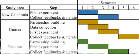
Focusing on three contrasted study areas is both a challenge and a strength. Indeed, the differences in terms of ecosystems, accessible data, societal issues and institutional context will inevitably increase the complexity of the organization and implementation of the project. However, since being able to deal with this complexity is one of the objectives of this project, confronting it is a necessary condition to ensure that the objectives are achieved. Moreover, differences in partnership maturity and access to data will allow us to implement various experiments throughout the project, starting with New Caledonia, where both partnerships and access to data are already well established.
9 Reproducibility and Application Potential to Other Study Contexts
Particular attention will be given to ensure reproducibility and open access to the research results and methodologies.
First, all software contributions will rely on open-source technologies and will also be distributed as open-source software. Whenever possible, attention will be paid to distributing extensively documented and user-friendly tools (e.g. R or Python packages, two widely used programming languages by ecologists and conservation scientists). Finally, all scientific publications resulting from this project will be published as far as possible in open access.
Although this project focuses on spatial planning in the context of tropical forests and their people, the methods will be generic and will therefore be applicable to other types of ecosystems (e.g. marine, freshwater, savanna). Moreover, as pointed out in Section 2, spatial planning also has applications in sustainable agricultural systems design, poverty alleviation through ecosystem service optimization, or sustainable city design. The application potential of this project to other disciplines and problems is therefore guaranteed.
10 Project TeamDescription
Currently, the team is mainly composed of me, Dimitri Justeau-Allaire, recruited permanently by the French National Research Institute for Sustainable Development (IRD) to conduct this project. This position includes possibilities for funding field missions and expatriation periods, which guarantees the long-term feasibility of this project. I am a computer scientist, with a strong background in CP and conservation planning, which was the subject of my PhD thesis. I will be supported by my laboratory, the AMAP Lab, which is a joint interdisciplinary research unit that conducts basic and applied research on plants and plant communities and has a long history of interdisciplinarity, with the involvement of ecological sciences, mathematics, and computer sciences. I will also rely on historical collaborations with the Laboratory of Computer Science, Robotics and Microelectronics of Montpellier (LIRMM), the IMT Atlantique, and the New Caledonian Institute of Agronomy (IAC). As the project is just starting, I will also look for additional sources of funding to involve more people in the projects (e.g. PhDs, postdocs, engineers, technicians) and expect new teammembers to join as soon as possible.
Ethical Statement
There are no ethical issues.
Acknowledgments
I acknowledge the IRD, which believed in this project and funded it. I also acknowledge the AMAP Lab in Noumea (New Caledonia) and Montpellier (France), and the IAC, who have offered me an exceptional working environment for several years. I thank Philippe Birnbaum, Xavier Lorca, Philippe Vismara, Ghislain Vielledent, Thomas Ibanez, Charles Prud'homme, and Jeffrey Hanson, who all have been a source of inspiration to design this project. I also thank Camille Salmon for her daily support. Finally, I am grateful to the two anonymous reviewers who helped to greatly improve this project proposal.
@inproceedings{ijcai2023p707,
  title     = {AI and Decision Support for Sustainable Socio-Ecosystems},
  author    = {Justeau-Allaire, Dimitri},
  booktitle = {Proceedings of the Thirty-Second International Joint Conference on
               Artificial Intelligence, {IJCAI-23}},
  publisher = {International Joint Conferences on Artificial Intelligence Organization},
  editor    = {Edith Elkind},
  pages     = {6370--6377},
  year      = {2023},
  month     = {8},
  note      = {AI for Good - Projects},
  doi       = {10.24963/ijcai.2023/707},
  url       = {https://doi.org/10.24963/ijcai.2023/707},
}
TY - CPAPER TI - AI and Decision Support for Sustainable Socio-Ecosystems AU - Justeau-Allaire, Dimitri T2 - Proceedings of the Thirty-Second International Joint Conference on Artificial Intelligence, IJCAI-23 PB - International Joint Conferences on Artificial Intelligence Organization PY - 2023 SP - 6370 EP - 6377 DO - 10.24963/ijcai.2023/707 UR - https://doi.org/10.24963/ijcai.2023/707 ER -Copied
Machine-readable versions of this paper, for tools and AI agents: